IMAGES TAKEN NEAR TO
Darrell Close, CHELMSFORD, CM1 4EL
Introduction
This page details the photographs taken nearby to Darrell Close, CM1 4EL by members of the Geograph project.
The Geograph project started in 2005 with the aim of publishing, organising and preserving representative images for every square kilometre of Great Britain, Ireland and the Isle of Man.

There are currently over 7.5m images from over14,400 individuals and you can help contribute to the project by visiting https://www.geograph.org.uk
Image Map (Loading...)


Getting Data...Please wait
Leaflet Map data © OpenStreetMap
Images are licensed for reuse under creativecommons.org/licenses/by-sa/2.0
Notes
- Clicking on the map will re-center to the selected point.
- The higher the marker number, the further away the image location is from the centre of the postcode.
Image Listing (9 Images Found)
Images are licensed for reuse under creativecommons.org/licenses/by-sa/2.0
Image
Details
Distance
1
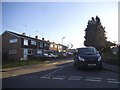
Main Road at the junction of Valley Bridge
The bridge goes over the river Chelmer on the left.
Image: © David Howard
Taken: 15 May 2012
0.11 miles
2
Broomfield Road nears the Valley Bridge turning
Valley Bridge is a short link over the Chelmer to the A1016 Chelmer Valley road.
Image: © Robin Webster
Taken: 15 Sep 2011
0.12 miles
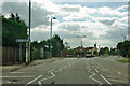
3
Broomfield Road at the junction of Patching Hall Lane
Image: © David Howard
Taken: 15 May 2012
0.18 miles
5

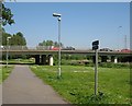
River Chelmer
View from Valley Bridge, Chelmsford.
Image: © Wayland Smith
Taken: 3 Oct 2021
0.20 miles
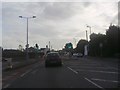
6
Valley Bridge
Link between the A138 and the B1003.
Image: © John Myers
Taken: 6 May 2008
0.20 miles
7
Aubrey Close
Residential road near Chelmsford.
Image: © Wayland Smith
Taken: 3 Oct 2021
0.21 miles
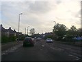
8
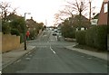
Crossroads at the end of Rutland Road
This view is looking down Rutland Road to the junction with Patching Hall Lane. From the junction, the road ahead is Sunrise Avenue.
Image: © Robert Edwards
Taken: 19 Feb 2010
0.21 miles