IMAGES TAKEN NEAR TO
Patching Hall Lane, CHELMSFORD, CM1 4BY
Introduction
This page details the photographs taken nearby to Patching Hall Lane, CM1 4BY by members of the Geograph project.
The Geograph project started in 2005 with the aim of publishing, organising and preserving representative images for every square kilometre of Great Britain, Ireland and the Isle of Man.

There are currently over 7.5m images from over14,400 individuals and you can help contribute to the project by visiting https://www.geograph.org.uk
Image Map (Loading...)


Getting Data...Please wait
Leaflet Map data © OpenStreetMap
Images are licensed for reuse under creativecommons.org/licenses/by-sa/2.0
Notes
- Clicking on the map will re-center to the selected point.
- The higher the marker number, the further away the image location is from the centre of the postcode.
Image Listing (8 Images Found)
Images are licensed for reuse under creativecommons.org/licenses/by-sa/2.0
Image
Details
Distance
1
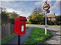
Postbox at Chelmsford
CM1 399. Royal Mail list this box as 'CM1 399D Woodhall Road'.
Image: © David Bremner
Taken: 2 Nov 2022
0.03 miles
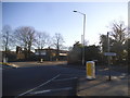
4
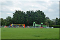
Playground, Newlands Spring
This recreation ground has had an overhaul recently, with new play apparatus and a better car park.
Image: © Robin Webster
Taken: 28 Jul 2012
0.17 miles
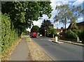
5
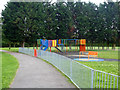
Play area, Newlands Spring
One of several small areas around here in the recreation ground, possibly age targetted.
Image: © Robin Webster
Taken: 28 Jul 2012
0.20 miles
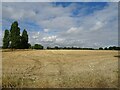
6
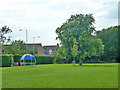
Corner of Newlands Spring recreation ground
Image: © Robin Webster
Taken: 28 Jul 2012
0.23 miles