IMAGES TAKEN NEAR TO
Ingrave Road, BRENTWOOD, CM14 9ST
Introduction
This page details the photographs taken nearby to Ingrave Road, CM14 9ST by members of the Geograph project.
The Geograph project started in 2005 with the aim of publishing, organising and preserving representative images for every square kilometre of Great Britain, Ireland and the Isle of Man.

There are currently over 7.5m images from over14,400 individuals and you can help contribute to the project by visiting https://www.geograph.org.uk
Image Map (Loading...)


Getting Data...Please wait
Leaflet Map data © OpenStreetMap
Images are licensed for reuse under creativecommons.org/licenses/by-sa/2.0
Notes
- Clicking on the map will re-center to the selected point.
- The higher the marker number, the further away the image location is from the centre of the postcode.
Image Listing (125 Images Found)
Images are licensed for reuse under creativecommons.org/licenses/by-sa/2.0
Image
Details
Distance
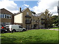
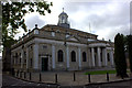
3
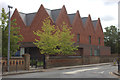
New development opposite Brentwood cathedral
An interesting bit of architecture although I do not know what its purpose is.
Image: © Robert Eva
Taken: 11 Sep 2017
0.05 miles
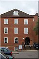
4
Flats off Seven Arches Road
The former Olde Log Restaurant
Image: © Geographer
Taken: 19 Sep 2015
0.07 miles
5
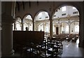
St Mary & St Helen, Roman Catholic Cathedral, Brentwood - Interior
Image: © John Salmon
Taken: 13 Oct 2011
0.08 miles
6
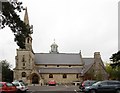
St Mary & St Helen, Roman Catholic Cathedral, Brentwood
Image: © John Salmon
Taken: 13 Oct 2011
0.08 miles
7
St Mary & St Helen, Roman Catholic Cathedral, Brentwood
Image: © John Salmon
Taken: 13 Oct 2011
0.08 miles
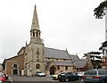
8
Brentwood cathedral
RC cathedral of St Mary and St Helen
Image: © Robert Eva
Taken: 11 Sep 2017
0.08 miles
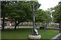
9
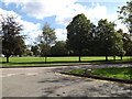
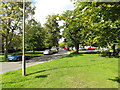
Shenfield Common, Brentwood
Off Seven Arches Road
Image: © Geographer
Taken: 19 Sep 2015
0.09 miles