IMAGES TAKEN NEAR TO
Royds Lane, BRENTWOOD, CM14 5TP
Introduction
This page details the photographs taken nearby to Royds Lane, CM14 5TP by members of the Geograph project.
The Geograph project started in 2005 with the aim of publishing, organising and preserving representative images for every square kilometre of Great Britain, Ireland and the Isle of Man.

There are currently over 7.5m images from over14,400 individuals and you can help contribute to the project by visiting https://www.geograph.org.uk
Image Map (Loading...)


Getting Data...Please wait
Leaflet Map data © OpenStreetMap
Images are licensed for reuse under creativecommons.org/licenses/by-sa/2.0
Notes
- Clicking on the map will re-center to the selected point.
- The higher the marker number, the further away the image location is from the centre of the postcode.
Image Listing (10 Images Found)
Images are licensed for reuse under creativecommons.org/licenses/by-sa/2.0
Image
Details
Distance
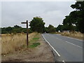
1
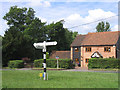
Signpost, Navestock Side, Brentwood, Essex
A nice black and white wooden signpost at junction of Navestockside and Snakes Hill
Image: © John Winfield
Taken: 11 Jul 2005
0.14 miles
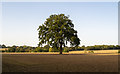
5
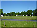
Cricket match, Navestock Side
A perfect day for cricket.
Image: © Robin Webster
Taken: 26 May 2012
0.22 miles
6
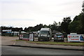
Time 4 Pets on Ongar Road, Kelvedon Hatch
Image: © David Howard
Taken: 25 May 2019
0.22 miles
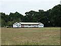
8
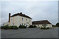
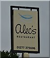
Alec's Restaurant, Navestock Side
The former Green Man public house - see Image]
Image: © JThomas
Taken: 24 Aug 2022
0.23 miles
10
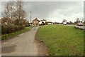
Part of the small green at Navestock Side
Image: © Robert Edwards
Taken: 19 Mar 2008
0.23 miles