IMAGES TAKEN NEAR TO
Howard Lodge Road, BRENTWOOD, CM14 5TG
Introduction
This page details the photographs taken nearby to Howard Lodge Road, CM14 5TG by members of the Geograph project.
The Geograph project started in 2005 with the aim of publishing, organising and preserving representative images for every square kilometre of Great Britain, Ireland and the Isle of Man.

There are currently over 7.5m images from over14,400 individuals and you can help contribute to the project by visiting https://www.geograph.org.uk
Image Map (Loading...)


Getting Data...Please wait
Leaflet Map data © OpenStreetMap
Images are licensed for reuse under creativecommons.org/licenses/by-sa/2.0
Notes
- Clicking on the map will re-center to the selected point.
- The higher the marker number, the further away the image location is from the centre of the postcode.
Image Listing (4 Images Found)
Images are licensed for reuse under creativecommons.org/licenses/by-sa/2.0
Image
Details
Distance
1
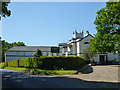
Dudbrook Hall
A 'care centre' according to the sign, actually a care home, it is surprising they do not use the more homely term.
Image: © Robin Webster
Taken: 26 May 2012
0.09 miles
2

Crossroads, Beacon Hill
Ongar and Epping far left, Kelvedon Common and Brentwood near right, Kelvedon Hatch and Blackmore far right, and Navestock and Havering near left.
Image: © Robin Webster
Taken: 26 May 2012
0.13 miles
3

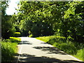
Beacon Hill Road, near Kelvedon Hatch
Beacon Hill Road, near Kelvedon Hatch in Essex, is shaded by woodland.
Image: © Malc McDonald
Taken: 7 Jun 2015
0.19 miles
4
Church Road, near Kelvedon Hatch
Sunlight and shadows on Church Lane, near Kelvedon Hatch in Essex.
Image: © Malc McDonald
Taken: 7 Jun 2015
0.22 miles