IMAGES TAKEN NEAR TO
Tanhouse Lane, BRENTWOOD, CM14 5SP
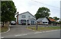
Introduction
This page details the photographs taken nearby to Tanhouse Lane, CM14 5SP by members of the Geograph project.
The Geograph project started in 2005 with the aim of publishing, organising and preserving representative images for every square kilometre of Great Britain, Ireland and the Isle of Man.

There are currently over 7.5m images from over14,400 individuals and you can help contribute to the project by visiting https://www.geograph.org.uk
Image Map
Images are licensed for reuse under creativecommons.org/licenses/by-sa/2.0
Notes
- Clicking on the map will re-center to the selected point.
- The higher the marker number, the further away the image location is from the centre of the postcode.
Image Listing (22 Images Found)
Images are licensed for reuse under creativecommons.org/licenses/by-sa/2.0
Image
Details
Distance
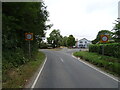
1
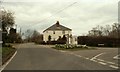
Road junction at South Weald Common
The road on the right is Dytchleys Lane and the other road is Horseman Side.
Image: © Robert Edwards
Taken: 19 Mar 2008
0.01 miles
2
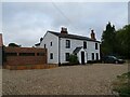
Former King William IV pub, South Weald Common
Now a private residence.
See also Image]
Image: © JThomas
Taken: 24 Aug 2022
0.02 miles
3
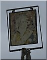
Sign for the King William IV pub, South Weald Common
The name is now barely legible.
Image: © JThomas
Taken: 24 Aug 2022
0.02 miles
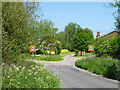
4
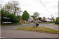
Junction at Tan House Lane
This is the Junction of Tan House Lane, Horseman Side and Dytchleys Road
Image: © Glyn Baker
Taken: 15 May 2015
0.02 miles
7
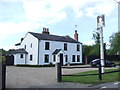
Former King William IV pub, South Weald Common
The sign by the roadside indicates that this building used to be a pub, the King William IV. It is now a private house.
Image: © Malc McDonald
Taken: 25 May 2013
0.02 miles
8
North end of Dytchleys Road
Horseman Side left, Tan House Lane right, a private drive to Bower Farm straight on.
Image: © Robin Webster
Taken: 26 May 2012
0.02 miles
10
Farmland, Horseman Side
The road called Horseman Side runs along behind the hedge (and ditch). The field is part of the former Navestock Common, which has long been enclosed as private farmland. Navestock and South Weald Commons were once an extensive belt. Horseman Side appears to form the northern boundary.
Image: © Robin Webster
Taken: 26 May 2012
0.07 miles