IMAGES TAKEN NEAR TO
Pilgrims Lane, BRENTWOOD, CM14 5RX
Introduction
This page details the photographs taken nearby to Pilgrims Lane, CM14 5RX by members of the Geograph project.
The Geograph project started in 2005 with the aim of publishing, organising and preserving representative images for every square kilometre of Great Britain, Ireland and the Isle of Man.

There are currently over 7.5m images from over14,400 individuals and you can help contribute to the project by visiting https://www.geograph.org.uk
Image Map (Loading...)


Getting Data...Please wait
Leaflet Map data © OpenStreetMap
Images are licensed for reuse under creativecommons.org/licenses/by-sa/2.0
Notes
- Clicking on the map will re-center to the selected point.
- The higher the marker number, the further away the image location is from the centre of the postcode.
Image Listing (5 Images Found)
Images are licensed for reuse under creativecommons.org/licenses/by-sa/2.0
Image
Details
Distance
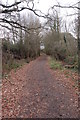
1
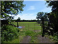
Footpath to Coxtie Green Road
This is the view from Pilgrim's Lane, not far from St Paul's Church at Bentley Common.
Image: © Marathon
Taken: 3 Jun 2017
0.18 miles
2
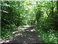
Pilgrim's Lane
Pilgrim's Lane is ancient and gets its name as in the Middle Ages it was a route taken by pilgrims on their way to Canterbury. It is here passing Pilgrim's Hall which is on the left, and a small pond is on the right.
Image: © Marathon
Taken: 3 Jun 2017
0.22 miles
3
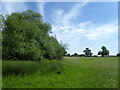
Footpath to Coxtie Green Road
The houses along Coxtie Green Road as well as Red Lion Farm can be seen in the distance.
Image: © Marathon
Taken: 3 Jun 2017
0.23 miles
4
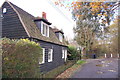
Cottage in Pilgrim's Lane
The lane runs between Bentley Common and Pilgrim's Hatch.
Image: © Trevor Harris
Taken: 3 Dec 2011
0.23 miles
5
Hullets Lane
About 100 - 200 m from the north end of the lane showing the good surface and lack of vehicle damage.
Image: © Hugh Gorton
Taken: 12 Jan 2015
0.25 miles