IMAGES TAKEN NEAR TO
Coxtie Green Road, BRENTWOOD, CM14 5RH
Introduction
This page details the photographs taken nearby to Coxtie Green Road, CM14 5RH by members of the Geograph project.
The Geograph project started in 2005 with the aim of publishing, organising and preserving representative images for every square kilometre of Great Britain, Ireland and the Isle of Man.

There are currently over 7.5m images from over14,400 individuals and you can help contribute to the project by visiting https://www.geograph.org.uk
Image Map
Images are licensed for reuse under creativecommons.org/licenses/by-sa/2.0
Notes
- Clicking on the map will re-center to the selected point.
- The higher the marker number, the further away the image location is from the centre of the postcode.
Image Listing (9 Images Found)
Images are licensed for reuse under creativecommons.org/licenses/by-sa/2.0
Image
Details
Distance
1
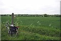
Carlton Corsa by the Footpath to Horsman Side
Not much sign of the footpath across the field. The bike is a 1973 Carlton Corsa one not very careful owner!
Image: © Glyn Baker
Taken: 15 May 2015
0.15 miles
2
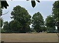
Parched grassland off Coxtie Green Road
Weald Park Golf Club beyond.
Image: © JThomas
Taken: 24 Aug 2022
0.17 miles
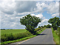
3
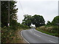
Bend in Coxtie Green Road
Towards Coxtie Green.
Image: © JThomas
Taken: 24 Aug 2022
0.17 miles
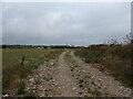
4
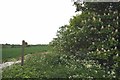
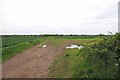
Footpath to Waterhales Farm
On this footpath there is Image passing
Image: © Glyn Baker
Taken: 15 May 2015
0.18 miles
5
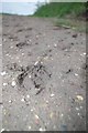
Evidence of Deer
My best guess is this is a footprint of a Roe deer. There were plenty to be glimpsed especially at a distance.
Image: © Glyn Baker
Taken: 15 May 2015
0.20 miles
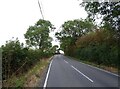
8
Coxtie Green Road
Looking towards Coxtie Green.
Image: © Robin Webster
Taken: 30 Jun 2012
0.23 miles
9
Towards Waterhales Farm
Image: © Glyn Baker
Taken: 15 May 2015
0.24 miles