IMAGES TAKEN NEAR TO
Weald Road, BRENTWOOD, CM14 5QL
Introduction
This page details the photographs taken nearby to Weald Road, CM14 5QL by members of the Geograph project.
The Geograph project started in 2005 with the aim of publishing, organising and preserving representative images for every square kilometre of Great Britain, Ireland and the Isle of Man.

There are currently over 7.5m images from over14,400 individuals and you can help contribute to the project by visiting https://www.geograph.org.uk
Image Map (Loading...)


Getting Data...Please wait
Leaflet Map data © OpenStreetMap
Images are licensed for reuse under creativecommons.org/licenses/by-sa/2.0
Notes
- Clicking on the map will re-center to the selected point.
- The higher the marker number, the further away the image location is from the centre of the postcode.
Image Listing (99 Images Found)
Images are licensed for reuse under creativecommons.org/licenses/by-sa/2.0
Image
Details
Distance
1
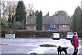
Belvedere Car Park, South Weald Country Park
Close to the area where the original house stood.
Image: © Trevor Harris
Taken: 3 Dec 2011
0.01 miles
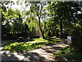
2
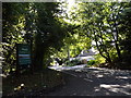
Entrance to Weald Country Park
Off Weald Road
Image: © Geographer
Taken: 19 Sep 2015
0.02 miles
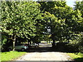
4
Entrance road to Weald Country Park
This entrance from Weald Road.
Image: © Roger Jones
Taken: 26 Jul 2012
0.04 miles
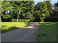
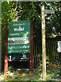
5
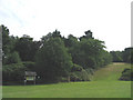
Weald Country Park
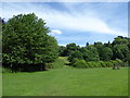
At nearly 500 acres, Weald Country Park is the largest of the Essex County Council Country Parks. Parkland has been established here for more than 700 years. In the Middle Ages Weald Country Park was part of a hunting ground, used by medieval monarchs and also by the abbots of Waltham. The lakes, the tree-lined avenues, and large parkland trees are the result of the landscaping carried out in the 18th century.
The Country Park consists of woodland and grassland, and has two lakes as well as several ponds. A map of Weald Country Park can be seen at http://www.visitparks.co.uk/media/1021/weald-country-park-map.pdf See also http://www.visitparks.co.uk/places/weald-country-park/
This is on the southern edge of the Country Park, not far from St Peter's Church, South Weald.
Image: © Marathon
Taken: 3 Jun 2017
0.04 miles
6
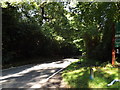
Weald Road, South Weald
At Weald Country Park
Image: © Geographer
Taken: 19 Sep 2015
0.04 miles
7
Weald Road, South Weald
At Weald Country Park
Image: © Geographer
Taken: 19 Sep 2015
0.04 miles
9
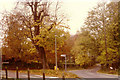
Autumn at South Weald, Essex
The road ahead goes up towards Navestock, and to the left is the way to Brook Street, the A12 and Junction 28 on the M25
Image: © Derek Voller
Taken: Unknown
0.06 miles
10
Weald Country Park, South Weald, Essex
The photograph shows the area of the park which has been designated for the mountain bike event in the 2012 Olympic Games! The nearest thing that Essex has to a mountain...
Image: © John Winfield
Taken: 9 Aug 2005
0.06 miles