IMAGES TAKEN NEAR TO
Sandpit Lane, BRENTWOOD, CM14 5QD
Introduction
This page details the photographs taken nearby to Sandpit Lane, CM14 5QD by members of the Geograph project.
The Geograph project started in 2005 with the aim of publishing, organising and preserving representative images for every square kilometre of Great Britain, Ireland and the Isle of Man.

There are currently over 7.5m images from over14,400 individuals and you can help contribute to the project by visiting https://www.geograph.org.uk
Image Map (Loading...)


Getting Data...Please wait
Leaflet Map data © OpenStreetMap
Images are licensed for reuse under creativecommons.org/licenses/by-sa/2.0
Notes
- Clicking on the map will re-center to the selected point.
- The higher the marker number, the further away the image location is from the centre of the postcode.
Image Listing (4 Images Found)
Images are licensed for reuse under creativecommons.org/licenses/by-sa/2.0
Image
Details
Distance
1
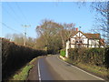
Sandpit Lane, near Brentwood
Sandpit Lane is a minor road passing through Essex countryside near Brentwood.
Image: © Malc McDonald
Taken: 18 Jan 2020
0.09 miles
2
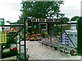
Sow & Grow Garden Centre, Ongar Road, Brentwood
Image: © Alex McGregor
Taken: 9 Jun 2011
0.19 miles
3
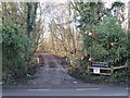
Riding and cycling route, near Brentwood
The entrance to a track for cycling and horse-riding in Weald Country Park, in Essex countryside near Brentwood.
This image was taken on a chilly but very sunny January day. Many of trees were bare, the sun was low in the sky and shadows were long.
Image: © Malc McDonald
Taken: 18 Jan 2020
0.20 miles
4

Danbury Close at the junction of Sandpit Lane
Image: © David Howard
Taken: 3 Sep 2017
0.25 miles