IMAGES TAKEN NEAR TO
Tern Way, BRENTWOOD, CM14 5NZ
Introduction
This page details the photographs taken nearby to Tern Way, CM14 5NZ by members of the Geograph project.
The Geograph project started in 2005 with the aim of publishing, organising and preserving representative images for every square kilometre of Great Britain, Ireland and the Isle of Man.

There are currently over 7.5m images from over14,400 individuals and you can help contribute to the project by visiting https://www.geograph.org.uk
Image Map
Images are licensed for reuse under creativecommons.org/licenses/by-sa/2.0
Notes
- Clicking on the map will re-center to the selected point.
- The higher the marker number, the further away the image location is from the centre of the postcode.
Image Listing (61 Images Found)
Images are licensed for reuse under creativecommons.org/licenses/by-sa/2.0
Image
Details
Distance
1
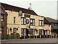
'The Bull' inn
This inn stands along the A.1023 that used to be the A.12
Image: © Robert Edwards
Taken: 14 Feb 2007
0.01 miles
2
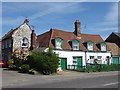
Old buildings on Brook Street
These buildings look like they date from when Brook Street formed the main road from London into Essex and on to Chelmsford and Colchester. The cottages look very old and the building on the left looks very intriguing.
Image: © Marathon
Taken: 10 May 2017
0.03 miles
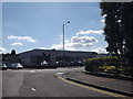
4
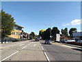
A1023 Brook Street, Brook Street
Approaching the junction with Mascalls Lane
Image: © Geographer
Taken: 19 Sep 2015
0.07 miles
5
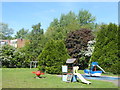
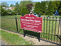
River Road Play Space
This small children's play area is located between River Road and the Ingrebourne River. The play area is on the western edge of Brentwood and has the sound of traffic on the A12 which is just beyond the river, hidden in the trees on the far side of the grass.
Image: © Marathon
Taken: 10 May 2017
0.09 miles
6
Spital Lane, Brook Street
At the junction with the A1023 Brook Street & A1023 London Road
Image: © Geographer
Taken: 19 Sep 2015
0.09 miles
7
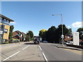
A1023 Brook Street, Brook Street
At the junction with Spital & Mascalls Lanes
Image: © Geographer
Taken: 19 Sep 2015
0.09 miles
8
River Road Play Space
This small children's play area is located between River Road and the Ingrebourne River. The play area is on the western edge of Brentwood and has the sound of traffic on the A12 which is just beyond the river, hidden in the trees on the far side of the grass.
Image: © Marathon
Taken: 10 May 2017
0.09 miles
9
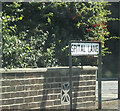
Spital Lane sign
On Spital Lane at the junction with the A1023 Brook Street & A1023 London Road
Image: © Geographer
Taken: 19 Sep 2015
0.09 miles
10
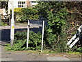
Mascalls Lane sign
On Mascalls Lane at the junction with Brook Street & A1023 London Road
Image: © Geographer
Taken: 19 Sep 2015
0.10 miles