IMAGES TAKEN NEAR TO
The Grove, BRENTWOOD, CM14 5NS
Introduction
This page details the photographs taken nearby to The Grove, CM14 5NS by members of the Geograph project.
The Geograph project started in 2005 with the aim of publishing, organising and preserving representative images for every square kilometre of Great Britain, Ireland and the Isle of Man.

There are currently over 7.5m images from over14,400 individuals and you can help contribute to the project by visiting https://www.geograph.org.uk
Image Map
Images are licensed for reuse under creativecommons.org/licenses/by-sa/2.0
Notes
- Clicking on the map will re-center to the selected point.
- The higher the marker number, the further away the image location is from the centre of the postcode.
Image Listing (50 Images Found)
Images are licensed for reuse under creativecommons.org/licenses/by-sa/2.0
Image
Details
Distance
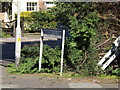
2
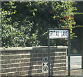
Spital Lane sign
On Spital Lane at the junction with the A1023 Brook Street & A1023 London Road
Image: © Geographer
Taken: 19 Sep 2015
0.07 miles
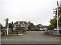
3
Spital Lane, Brook Street
At the junction with the A1023 Brook Street & A1023 London Road
Image: © Geographer
Taken: 19 Sep 2015
0.08 miles
4
A1023 Brook Street, Brook Street
At the junction with Spital & Mascalls Lanes
Image: © Geographer
Taken: 19 Sep 2015
0.08 miles
5
Mascalls Lane sign
On Mascalls Lane at the junction with Brook Street & A1023 London Road
Image: © Geographer
Taken: 19 Sep 2015
0.08 miles
6
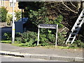
Mascalls Lane sign
On Mascalls Lane at the junction with Brook Street & A1023 London Road
Image: © Geographer
Taken: 19 Sep 2015
0.08 miles
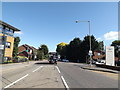
7
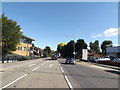
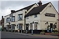
A1023 Brook Street, Brook Street
Approaching the junction with Mascalls Lane
Image: © Geographer
Taken: 19 Sep 2015
0.10 miles
8
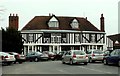
'The Marygreen Manor Hotel'
This was originally a 16th century Manor House.
Image: © Robert Edwards
Taken: 14 Feb 2007
0.11 miles
10
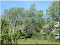
Horse pasture alongside Spital Lane
This horse seemed to have the pasture all to itself. The Ingrebourne River marks the boundary to the left while the A12 is just beyond the trees ahead.
Image: © Marathon
Taken: 10 May 2017
0.11 miles