IMAGES TAKEN NEAR TO
The Lawns, Uplands Road, BRENTWOOD, CM14 5AW
Introduction
This page details the photographs taken nearby to The Lawns, Uplands Road, CM14 5AW by members of the Geograph project.
The Geograph project started in 2005 with the aim of publishing, organising and preserving representative images for every square kilometre of Great Britain, Ireland and the Isle of Man.

There are currently over 7.5m images from over14,400 individuals and you can help contribute to the project by visiting https://www.geograph.org.uk
Image Map (Loading...)


Getting Data...Please wait
Leaflet Map data © OpenStreetMap
Images are licensed for reuse under creativecommons.org/licenses/by-sa/2.0
Notes
- Clicking on the map will re-center to the selected point.
- The higher the marker number, the further away the image location is from the centre of the postcode.
Image Listing (16 Images Found)
Images are licensed for reuse under creativecommons.org/licenses/by-sa/2.0
Image
Details
Distance
1
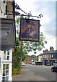
Outside The Brave Nelson
Looking along Woodman Road from in front of the local pub.
Image: © Des Blenkinsopp
Taken: 28 Jun 2024
0.09 miles
2
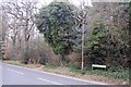
Path into Hart's Wood
Opposite the junction of Woodman Road and Hartswood Road, this path, popular with dog walkers, leads into the woods.
Image: © Trevor Harris
Taken: 19 Mar 2009
0.11 miles
3
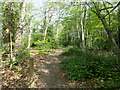
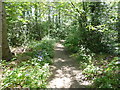
Path in Hart's Wood
Hart's Wood is at the northern end of Thorndon Country Park. Thorndon Country Park is divided into Thorndon Park North, with the Countryside Centre, and Thorndon Park South. These areas are linked by the 'Old Park', which is owned by the Woodland Trust, and 'Old Thorndon Pasture', which is owned by Essex County Council.
The Countryside Centre in Thorndon Park North was built from timber blown over in the 1987 storms in the two parks. It has a permanent exhibition, a shop selling gifts and refreshments, and a schools' room.
See map at http://www.visitparks.co.uk/media/1017/thorndon-country-park-brentwood-map.pdf
Image: © Marathon
Taken: 10 May 2017
0.12 miles
4
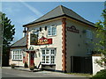
Brave Nelson Public House, Woodman Road
Image: © Robin Lucas
Taken: 30 Apr 2007
0.12 miles
6
Hartswood Road, Brentwood
This is on the corner of South Drive. Hart's Wood is on the other side of Hartswood Road - see http://www.geograph.org.uk/photo/5392742
Image: © Marathon
Taken: 10 May 2017
0.16 miles
7
Path in Hart's Wood
Hart's Wood is at the northern end of Thorndon Country Park. Thorndon Country Park is divided into Thorndon Park North, with the Countryside Centre, and Thorndon Park South. These areas are linked by the 'Old Park', which is owned by the Woodland Trust, and 'Old Thorndon Pasture', which is owned by Essex County Council.
The Countryside Centre in Thorndon Park North was built from timber blown over in the 1987 storms in the two parks. It has a permanent exhibition, a shop selling gifts and refreshments, and a schools' room.
See map at http://www.visitparks.co.uk/media/1017/thorndon-country-park-brentwood-map.pdf
Image: © Marathon
Taken: 10 May 2017
0.16 miles
8
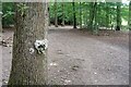
Clay Face on a Tree
There were quite a few of these stuck onto the trees just around here. Lumps of clay from a stream or puddles splatted onto the tree bark and worked into various odd faces. This is one of the best, with green eyes and a leafy beard and an impressive mustache made out of moss or something.
Image: © Des Blenkinsopp
Taken: 28 Jun 2024
0.16 miles
9
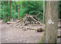
Structure in Hartswood
One of those dead branch arrangements that the kids build in woodlands all over the place. More unusual is the little face made out of clay stuck onto the bark of a tree. There were a lot of them just here, with a stream nearby as the source of the clay.
Image: © Des Blenkinsopp
Taken: 28 Jun 2024
0.17 miles
10
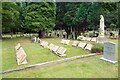
Woodman Road Cemetery
Some unusual book style memorials. From the inscriptions, this is a special plot reserved for a convent.
Image: © Des Blenkinsopp
Taken: 28 Jun 2024
0.18 miles