IMAGES TAKEN NEAR TO
Upper Ryle, BRENTWOOD, CM14 4YG
Introduction
This page details the photographs taken nearby to Upper Ryle, CM14 4YG by members of the Geograph project.
The Geograph project started in 2005 with the aim of publishing, organising and preserving representative images for every square kilometre of Great Britain, Ireland and the Isle of Man.

There are currently over 7.5m images from over14,400 individuals and you can help contribute to the project by visiting https://www.geograph.org.uk
Image Map
Images are licensed for reuse under creativecommons.org/licenses/by-sa/2.0
Notes
- Clicking on the map will re-center to the selected point.
- The higher the marker number, the further away the image location is from the centre of the postcode.
Image Listing (21 Images Found)
Images are licensed for reuse under creativecommons.org/licenses/by-sa/2.0
Image
Details
Distance
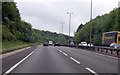
1
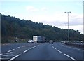
A12, Brentwood, Essex
Looking north-east from the Weald Road bridge.
Image: © John Winfield
Taken: 9 Aug 2005
0.08 miles
2
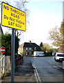
Sign on entrance to Costead Manor Road
Green Lane at the end of Costead Manor Road is marked on maps as a road.
See Image
Image: © terry joyce
Taken: 8 Dec 2009
0.11 miles
3
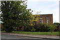
St George's Church, Greenshaw
Seen basking in the sunset on a beautiful spring evening. Looking north from Costead Manor Road.
Image: © Robert Lamb
Taken: 8 Apr 2011
0.12 miles
7
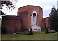
St George Church, Pilgrims Hatch, Essex
Image: © Peter Stack
Taken: 16 Oct 2009
0.12 miles
8
St George's Church on Ongar Road, Brentwood
Image: © David Howard
Taken: 25 May 2019
0.12 miles
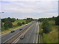
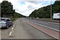
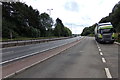
9

Lay-by by A12 eastbound outside Brentwood
A lay-by in a shallow wooded cutting to the west of Brentwood
Image: © David Smith
Taken: 14 Jun 2014
0.12 miles