IMAGES TAKEN NEAR TO
Kavanaghs Road, BRENTWOOD, CM14 4NB
Introduction
This page details the photographs taken nearby to Kavanaghs Road, CM14 4NB by members of the Geograph project.
The Geograph project started in 2005 with the aim of publishing, organising and preserving representative images for every square kilometre of Great Britain, Ireland and the Isle of Man.

There are currently over 7.5m images from over14,400 individuals and you can help contribute to the project by visiting https://www.geograph.org.uk
Image Map (Loading...)


Getting Data...Please wait
Leaflet Map data © OpenStreetMap
Images are licensed for reuse under creativecommons.org/licenses/by-sa/2.0
Notes
- Clicking on the map will re-center to the selected point.
- The higher the marker number, the further away the image location is from the centre of the postcode.
Image Listing (19 Images Found)
Images are licensed for reuse under creativecommons.org/licenses/by-sa/2.0
Image
Details
Distance
1

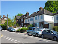
Ashford Avenue, Brentwood
Ashford Avenue is a residential road in Brentwood, in Essex.
This image was taken on a chilly but very sunny January day. Some of the trees were bare, the sun was low in the sky and shadows were long.
Image: © Malc McDonald
Taken: 18 Jan 2020
0.02 miles
2

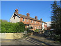
Kavanaghs Road, Brentwood
Kavanaghs Road is a residential road in Brentwood, in Essex.
This image was taken on a chilly but very sunny January day. The sun was low in the sky and shadows were long.
Image: © Malc McDonald
Taken: 18 Jan 2020
0.04 miles
4
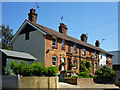
Kavanaghs Terrace, Brentwood
Kavanaghs Terrace is a short terrace of houses in Brentwood, in Essex.
This image was taken on a chilly but very sunny January day. The sun was low in the sky and shadows were long.
Image: © Malc McDonald
Taken: 18 Jan 2020
0.10 miles
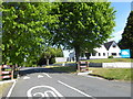
5
Kavanaghs Terrace
Off Kavanaghs Road.
Image: © Robin Webster
Taken: 26 May 2012
0.11 miles
6
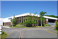
Premises on Hubert Road, Brentwood
At the time of this view, this housed Total Data Management, archiving specialists.
Image: © Robin Webster
Taken: 26 May 2012
0.13 miles
7
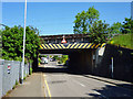
Railway bridge over Kavanaghs Road
The four-track Great Eastern main line crosses the road with 12' 6" clearance. There are substantial wasp-striped box girders on each side protecting the actual bridge structure from road vehicle strikes. The far side must be a little lower than this side, as there are rather more scrape marks on the girder.
Image: © Robin Webster
Taken: 26 May 2012
0.14 miles
8
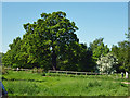
Warley Country Park
The edge of the area viewed from the Crescent Road entrance.
Image: © Robin Webster
Taken: 26 May 2012
0.15 miles
9

Honeypot Lane, Brentwood
Honeypot Lane is a residential road in Brentwood, in Essex.
This image was taken on a chilly but very sunny January day. The sun was low in the sky and shadows were long.
Image: © Malc McDonald
Taken: 18 Jan 2020
0.16 miles
10
South Weald Road
This is a private road leading to Homesteads Private Estate. The notice in addition to this information also said 'residents only' so I ventured no further than the view here from London Road. This was in the run up to the 2017 General Election so there were co-ordinated Conservative Party posters on either side of the entrance to the estate. The one on the left, like the one seen here on somebody's front lawn, was just out of the picture.
Image: © Marathon
Taken: 10 May 2017
0.18 miles