IMAGES TAKEN NEAR TO
The Close, Rose Valley, BRENTWOOD, CM14 4JA
Introduction
This page details the photographs taken nearby to The Close, Rose Valley, CM14 4JA by members of the Geograph project.
The Geograph project started in 2005 with the aim of publishing, organising and preserving representative images for every square kilometre of Great Britain, Ireland and the Isle of Man.

There are currently over 7.5m images from over14,400 individuals and you can help contribute to the project by visiting https://www.geograph.org.uk
Image Map
Images are licensed for reuse under creativecommons.org/licenses/by-sa/2.0
Notes
- Clicking on the map will re-center to the selected point.
- The higher the marker number, the further away the image location is from the centre of the postcode.
Image Listing (99 Images Found)
Images are licensed for reuse under creativecommons.org/licenses/by-sa/2.0
Image
Details
Distance
2
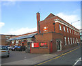
Brentwood Railway Station
Photograph taken in Alexander Road showing north side of the station, which is on the London Liverpool Street-Shenfield/Colchester line.
Image: © John Winfield
Taken: 8 Sep 2005
0.06 miles
3
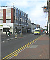
Wilsons Corner, Brentwood
Although the old Wilsons departmental store has been closed for many years, this junction is still carries the name.
Image: © John Winfield
Taken: 8 Sep 2005
0.06 miles
4
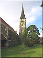
St. Thomas of Canterbury Parish Church, Brentwood
Built in 1883, this church is a Grade II* listed building. The name of the church reflects the long association between the town and St. Thomas a Becket.
Image: © John Winfield
Taken: 8 Sep 2005
0.06 miles
5
Brentwood Sorting Office
The Royal Mail sorting office is located behind the main post office in the High Street.
Image: © John Winfield
Taken: 8 Sep 2005
0.06 miles
6
"Blues & Twos", Brentwood High Street
Essex Ambulance on a 'shout' - looking west in the High Street.
Image: © John Winfield
Taken: 8 Sep 2005
0.06 miles
7
The Old Fire Station, Brentwood, Essex
This old fire station is located in Hart Street and is now a barber's shop (called "The Headquarters"!). I have been unable to discover when this station was in operation.
Image: © John Winfield
Taken: 8 Sep 2005
0.06 miles
8
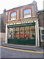
The old Lion & Lamb Public House, High Street, Brentwood.
I have used this WH Smiths for more years than I can recall but when I took this photograph I noticed the two plaques above each arch, depicting a lion and a lamb and the wrought iron arm for an inn sign. A bit of internet research shows that a 'Lion & Lamb'pub was in the High Street in 1895.
Image: © John Winfield
Taken: 8 Sep 2005
0.06 miles
9
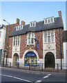
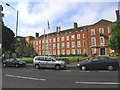
Brentwood Public School, Essex
The school was founded in 1557 and received its charter the following year.
Image: © John Winfield
Taken: 8 Sep 2005
0.06 miles
10
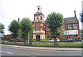
Brentwood Town Hall and Council Offices, Essex
Located in Ingrave Road.
Image: © John Winfield
Taken: 8 Sep 2005
0.06 miles