IMAGES TAKEN NEAR TO
Rose Valley, BRENTWOOD, CM14 4HZ
Introduction
This page details the photographs taken nearby to Rose Valley, CM14 4HZ by members of the Geograph project.
The Geograph project started in 2005 with the aim of publishing, organising and preserving representative images for every square kilometre of Great Britain, Ireland and the Isle of Man.

There are currently over 7.5m images from over14,400 individuals and you can help contribute to the project by visiting https://www.geograph.org.uk
Image Map (Loading...)


Getting Data...Please wait
Leaflet Map data © OpenStreetMap
Images are licensed for reuse under creativecommons.org/licenses/by-sa/2.0
Notes
- Clicking on the map will re-center to the selected point.
- The higher the marker number, the further away the image location is from the centre of the postcode.
Image Listing (71 Images Found)
Images are licensed for reuse under creativecommons.org/licenses/by-sa/2.0
Image
Details
Distance
1
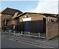
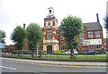
Brentwood Sea Cadets, King Edward Road, Brentwood
Image: © PAUL FARMER
Taken: 27 Oct 2015
0.07 miles
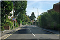
2
Queen's Road, Brentwood
Queen's Road was built up around the 1840s as Brentwood expanded southwards towards the newly-built railway. There are still some substantial Victorian villas here but there are newer buildings too. This is a stretch of the B186.
Image: © Stephen McKay
Taken: 11 Jan 2023
0.07 miles
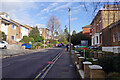
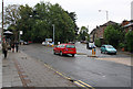
3
Queen's Road, Brentwood
Queen's Road is seen here running straight ahead from its junction with King's Road. Pedestrians might walk this way from the station to the town centre - it is quite a step.
Image: © Stephen McKay
Taken: 11 Jan 2023
0.09 miles
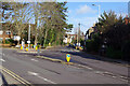
5
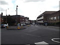
B186 Warley Hill, Brentwood
At the junction with the B185 King's Road & B186 Queen's Road
Image: © Geographer
Taken: 19 Sep 2015
0.10 miles
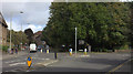
6
Kings Road, Queens Road
The roundabout at the junction with Queens Road, which can be seen in the centre of the photo. Kings Road continues up the hill on the left.
Image: © Martin Addison
Taken: 9 Sep 2008
0.10 miles
7
Roundabout at top of Warley Hill, Brentwood
Kings Road on the left, Queens Road on the right.
Image: © Robert Eva
Taken: 11 Sep 2017
0.10 miles
8
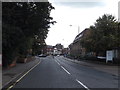
B185 King's Road, Brentwood
At the junction with the B186 Queen's Road & B186 Warley Hill
Image: © Geographer
Taken: 19 Sep 2015
0.11 miles
9
Brentwood Public School, Essex
The school was founded in 1557 and received its charter the following year.
Image: © John Winfield
Taken: 8 Sep 2005
0.11 miles
10
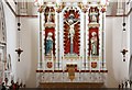
St Thomas of Canterbury, Brentwood - Reredos
Image: © John Salmon
Taken: 13 Oct 2011
0.11 miles