IMAGES TAKEN NEAR TO
Coptfold Road, BRENTWOOD, CM14 4FA
Introduction
This page details the photographs taken nearby to Coptfold Road, CM14 4FA by members of the Geograph project.
The Geograph project started in 2005 with the aim of publishing, organising and preserving representative images for every square kilometre of Great Britain, Ireland and the Isle of Man.

There are currently over 7.5m images from over14,400 individuals and you can help contribute to the project by visiting https://www.geograph.org.uk
Image Map (Loading...)


Getting Data...Please wait
Leaflet Map data © OpenStreetMap
Images are licensed for reuse under creativecommons.org/licenses/by-sa/2.0
Notes
- Clicking on the map will re-center to the selected point.
- The higher the marker number, the further away the image location is from the centre of the postcode.
Image Listing (114 Images Found)
Images are licensed for reuse under creativecommons.org/licenses/by-sa/2.0
Image
Details
Distance
1
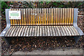
Chatty Bench
'Please sit here if you don't mind stopping for a chat'. Underneath it says 'Contact the Brentwood Community Tree for more support'.
Image: © Stephen McKay
Taken: 11 Jan 2023
0.01 miles
2
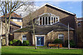
Brentwood United Reformed Church
This is the back of the grade II listed church the front of which dates from 1847.
Image: © Stephen McKay
Taken: 11 Jan 2023
0.02 miles
3
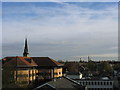
Brentwood Spires
Looking east with spire of St Thomas' church on left and those of Brentwood Cathedral on right.
Image: © John Winfield
Taken: 3 Dec 2005
0.03 miles
4
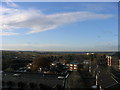
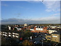
London from Essex
The distant skyline of London viewed from roof of multi-storey car park in Brentwood. The cluster of buildings on central horizon are at Canary Wharf and those just visible to the right are in City of London (approx. distance 22 miles)
Image: © John Winfield
Taken: 3 Dec 2005
0.05 miles
5
The Old Market Site, Brentwood
Market has long gone and now a car park and new housing development. A view to north-west from main car park with wooded area of South Weald Country Park on the horizon.
Image: © John Winfield
Taken: 3 Dec 2005
0.05 miles
6
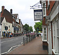
High Street Brentwood Essex
Looking east from the Information Centre
Image: © John Winfield
Taken: 17 Jun 2005
0.05 miles
7
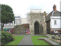
The Chapel of Thomas 'a Becket, High Street, Brentwood
The chapel was built in 1212 and is now a scheduled Ancient Monument and Grade II* listed building. All that remains is part of the tower and parts of the west and north wall.
Image: © John Winfield
Taken: 6 Aug 2005
0.05 miles
8
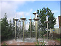
Fountains, Ongar Road, Brentwood
Located at the entrance to the new Sainsbury's superstore.
Image: © John Winfield
Taken: 8 Sep 2005
0.05 miles
9
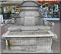
Horse Trough, High Street, Brentwood
I must have passed this horse trough hundreds of times - never really noticed it. Located at east end of the High Street near Wilson's Corner and bears date 1910 and names 'George & John Larkin'.
Image: © John Winfield
Taken: 8 Sep 2005
0.05 miles
10
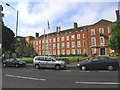
Brentwood Town Hall and Council Offices, Essex
Located in Ingrave Road.
Image: © John Winfield
Taken: 8 Sep 2005
0.05 miles