IMAGES TAKEN NEAR TO
Kings Road, BRENTWOOD, CM14 4EQ
Introduction
This page details the photographs taken nearby to Kings Road, CM14 4EQ by members of the Geograph project.
The Geograph project started in 2005 with the aim of publishing, organising and preserving representative images for every square kilometre of Great Britain, Ireland and the Isle of Man.

There are currently over 7.5m images from over14,400 individuals and you can help contribute to the project by visiting https://www.geograph.org.uk
Image Map (Loading...)


Getting Data...Please wait
Leaflet Map data © OpenStreetMap
Images are licensed for reuse under creativecommons.org/licenses/by-sa/2.0
Notes
- Clicking on the map will re-center to the selected point.
- The higher the marker number, the further away the image location is from the centre of the postcode.
Image Listing (68 Images Found)
Images are licensed for reuse under creativecommons.org/licenses/by-sa/2.0
Image
Details
Distance
1
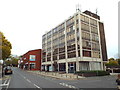
Office block on Warley Hill, Brentwood
An office block on Warley Hill, in Brentwood. Although this location isn't in the town centre, it is very close to the railway station.
Image: © Malc McDonald
Taken: 28 Oct 2017
0.02 miles
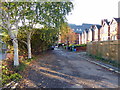
2
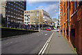
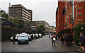
The Parade, Brentwood
The Parade leads up from Brentwood station towards the town centre.
Image: © Stephen McKay
Taken: 11 Jan 2023
0.03 miles
3
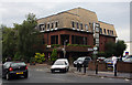
Highway House
Offices on the corner of Wharf Road and Kings Road, seen during the evening rush hour.
Image: © Martin Addison
Taken: 9 Sep 2008
0.03 miles
4
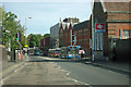
By Brentwood station
The road is Warley Hill, nearing the end of its not very steep descent.
Image: © Robin Webster
Taken: 15 Sep 2011
0.04 miles
5
Grey Start to the Day
The ramp outside Brentwood station, beside Kings Road. Office workers and school children start the walk up the hill on a damp September morning. The cabbies were doing a brisk trade, though I prefer to walk.
Image: © Martin Addison
Taken: 9 Sep 2008
0.04 miles
6
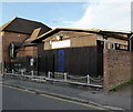
Brentwood Sea Cadets, King Edward Road, Brentwood
Image: © PAUL FARMER
Taken: 27 Oct 2015
0.07 miles
7
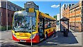
Brentwood Station bus stop
The unusual sign announces this bus stop as a "Public transport timing point". This means that a bus cannot leave early. (Not a problem in this case, as the 21 has arrived late on its afternoon journey from Ongar.)
Rather harshly, the sign also forbids the driver of an early bus from nipping off to use the station facilities.
Image: © Mark Percy
Taken: 7 Jul 2023
0.07 miles
8
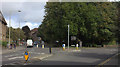
Roundabout at top of Warley Hill, Brentwood
Kings Road on the left, Queens Road on the right.
Image: © Robert Eva
Taken: 11 Sep 2017
0.07 miles
10
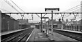
Brentwood & Warley Station
View westward, towards London; ex-GER Liverpool St. - Colchester etc. main line, electrified since 6/56. ('& Warley' was dropped in 1969).
Image: © Ben Brooksbank
Taken: 9 Apr 1961
0.08 miles