1
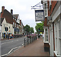
High Street Brentwood Essex
Looking east from the Information Centre
Image: © John Winfield
Taken: 17 Jun 2005
0.03 miles
2
The Chapel of Thomas 'a Becket, High Street, Brentwood
The chapel was built in 1212 and is now a scheduled Ancient Monument and Grade II* listed building. All that remains is part of the tower and parts of the west and north wall.
Image: © John Winfield
Taken: 6 Aug 2005
0.03 miles
3
Fountains, Ongar Road, Brentwood
Located at the entrance to the new Sainsbury's superstore.
Image: © John Winfield
Taken: 8 Sep 2005
0.03 miles
4
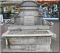
Horse Trough, High Street, Brentwood
I must have passed this horse trough hundreds of times - never really noticed it. Located at east end of the High Street near Wilson's Corner and bears date 1910 and names 'George & John Larkin'.
Image: © John Winfield
Taken: 8 Sep 2005
0.03 miles
5
Brentwood Town Hall and Council Offices, Essex
Located in Ingrave Road.
Image: © John Winfield
Taken: 8 Sep 2005
0.03 miles
6
Brentwood Public School, Essex
The school was founded in 1557 and received its charter the following year.
Image: © John Winfield
Taken: 8 Sep 2005
0.03 miles
7
The old Lion & Lamb Public House, High Street, Brentwood.
I have used this WH Smiths for more years than I can recall but when I took this photograph I noticed the two plaques above each arch, depicting a lion and a lamb and the wrought iron arm for an inn sign. A bit of internet research shows that a 'Lion & Lamb'pub was in the High Street in 1895.
Image: © John Winfield
Taken: 8 Sep 2005
0.03 miles
8
The Old Fire Station, Brentwood, Essex
This old fire station is located in Hart Street and is now a barber's shop (called "The Headquarters"!). I have been unable to discover when this station was in operation.
Image: © John Winfield
Taken: 8 Sep 2005
0.03 miles
9
"Blues & Twos", Brentwood High Street
Essex Ambulance on a 'shout' - looking west in the High Street.
Image: © John Winfield
Taken: 8 Sep 2005
0.03 miles
10
Brentwood Sorting Office
The Royal Mail sorting office is located behind the main post office in the High Street.
Image: © John Winfield
Taken: 8 Sep 2005
0.03 miles


