IMAGES TAKEN NEAR TO
Hart Street, BRENTWOOD, CM14 4AD
Introduction
This page details the photographs taken nearby to Hart Street, CM14 4AD by members of the Geograph project.
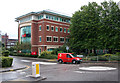
The Geograph project started in 2005 with the aim of publishing, organising and preserving representative images for every square kilometre of Great Britain, Ireland and the Isle of Man.

There are currently over 7.5m images from over14,400 individuals and you can help contribute to the project by visiting https://www.geograph.org.uk
Image Map (Loading...)


Getting Data...Please wait
Leaflet Map data © OpenStreetMap
Images are licensed for reuse under creativecommons.org/licenses/by-sa/2.0
Notes
- Clicking on the map will re-center to the selected point.
- The higher the marker number, the further away the image location is from the centre of the postcode.
Image Listing (89 Images Found)
Images are licensed for reuse under creativecommons.org/licenses/by-sa/2.0
Image
Details
Distance
1
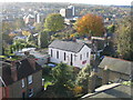
Crown Street Christian Fellowship, Brentwood
Image: © John Winfield
Taken: 3 Dec 2005
0.04 miles
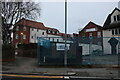
2
New housing development, Chatham Way off Kings Road, Brentwood
A new mixed development on the site of the old market.
Image: © John Winfield
Taken: 17 Sep 2005
0.05 miles
3
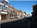
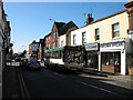
High Street, Brentwood
On a warm and sunny lunchtime in March. The Litten Tree public house nestles alongside the more traditional Swan.
Image: © Martin Addison
Taken: 13 Mar 2007
0.06 miles
4
Chatham Way
A new cul-de-sac off Kings Road with office developments. The large building is the UK headquarters of Océ, a company supplying printers and similar items.
Image: © Martin Addison
Taken: 9 Sep 2008
0.06 miles
5
High Street, Brentwood
Looking west towards the junction with Kings Road and Weald Road. Imperial Buses L104HHV, a Northern Counties Paladin bodied Dennis Dart, arrives at the Brentwood end of the 269 route from Grays.
Image: © Martin Addison
Taken: 13 Mar 2007
0.06 miles
6
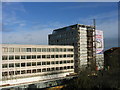
Becket House, Brentwood
New shops, offices and residential development on south side of Brentwood High Street.
Image: © John Winfield
Taken: 3 Dec 2005
0.07 miles
7
The Old Market Site, Brentwood
Market has long gone and now a car park and new housing development. A view to north-west from main car park with wooded area of South Weald Country Park on the horizon.
Image: © John Winfield
Taken: 3 Dec 2005
0.08 miles
8
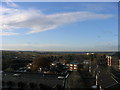
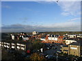
London from Essex
The distant skyline of London viewed from roof of multi-storey car park in Brentwood. The cluster of buildings on central horizon are at Canary Wharf and those just visible to the right are in City of London (approx. distance 22 miles)
Image: © John Winfield
Taken: 3 Dec 2005
0.08 miles
9
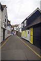
South Street Brentwood
A Brentwood back street
Image: © Glyn Baker
Taken: 6 Mar 2013
0.08 miles