IMAGES TAKEN NEAR TO
Lordship Road, CHELMSFORD, CM1 3RT
Introduction
This page details the photographs taken nearby to Lordship Road, CM1 3RT by members of the Geograph project.
The Geograph project started in 2005 with the aim of publishing, organising and preserving representative images for every square kilometre of Great Britain, Ireland and the Isle of Man.

There are currently over 7.5m images from over14,400 individuals and you can help contribute to the project by visiting https://www.geograph.org.uk
Image Map
Images are licensed for reuse under creativecommons.org/licenses/by-sa/2.0
Notes
- Clicking on the map will re-center to the selected point.
- The higher the marker number, the further away the image location is from the centre of the postcode.
Image Listing (13 Images Found)
Images are licensed for reuse under creativecommons.org/licenses/by-sa/2.0
Image
Details
Distance
1
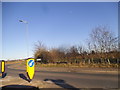
Lordship Road at the junction of Roxwell Road
Image: © David Howard
Taken: 25 Feb 2018
0.01 miles
2
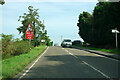
Lordship Road approaching A1060 roundabout
Image: © Robin Webster
Taken: 15 Sep 2011
0.05 miles
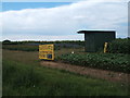
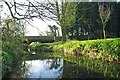
4
Warren Bridge
The road humps to cross the River Can. The Can shortly is shortly joined by the Wid and it later itself joins the Chelmer in the middle of Chelmsford.
Image: © Robin Webster
Taken: 15 Sep 2011
0.16 miles
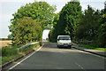
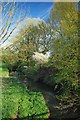
5
Warren Bridge
The far bridge carries Lordship Rd over the River Can
Image: © Glyn Baker
Taken: 6 Apr 2011
0.16 miles
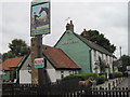
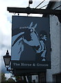
8
The Horse and Groom public house
On Roxwell Road.
Image: © JThomas
Taken: 5 Aug 2017
0.20 miles
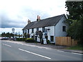
10
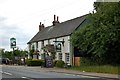
The Horse and Groom
Pub north of Writtle on Roxwell Road (A1060).
Image: © Trevor Harris
Taken: 9 Jun 2015
0.20 miles