IMAGES TAKEN NEAR TO
Writtle Road, CHELMSFORD, CM1 3RL
Introduction
This page details the photographs taken nearby to Writtle Road, CM1 3RL by members of the Geograph project.
The Geograph project started in 2005 with the aim of publishing, organising and preserving representative images for every square kilometre of Great Britain, Ireland and the Isle of Man.

There are currently over 7.5m images from over14,400 individuals and you can help contribute to the project by visiting https://www.geograph.org.uk
Image Map
Images are licensed for reuse under creativecommons.org/licenses/by-sa/2.0
Notes
- Clicking on the map will re-center to the selected point.
- The higher the marker number, the further away the image location is from the centre of the postcode.
Image Listing (14 Images Found)
Images are licensed for reuse under creativecommons.org/licenses/by-sa/2.0
Image
Details
Distance
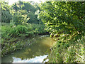
1
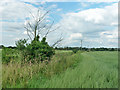
Sandy Brook
Probably more sandy than watery this time of year if you could see it. A tributary of the River Wid, some way ahead.
Image: © Robin Webster
Taken: 28 Jul 2012
0.13 miles
2
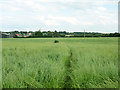
Footpath from Writtle to Widford
Crossing the Sandy Brook in the slight dip.
Image: © Robin Webster
Taken: 28 Jul 2012
0.13 miles

4
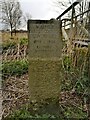
Writtle commemorative parish boundary stone
A commemorative boundary stone marking the eastern boundary of Writtle parish.
Milestone Society ID no. EX_WRIT05cm
Image: © Paul Jones
Taken: 1 Apr 2022
0.14 miles
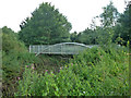
5
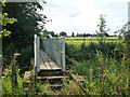
Footbridge over River Wid
On the footpath from Widford to Writtle.
Image: © Robin Webster
Taken: 28 Jul 2012
0.15 miles
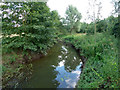
6
Footbridge over River Wid
On the footpath from Widford to Writtle.
Image: © Robin Webster
Taken: 28 Jul 2012
0.15 miles
9
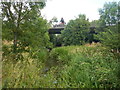
A414 Bridge Over the River Wid
The bridge carries the A414 Writtle bypass over the River Wid. The bypass was opened in August 1989.
Image: © Paul Franks
Taken: 22 Jul 2015
0.20 miles
10
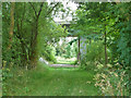
Farm underpass, A414
Two spans, a mostly hidden one on the right is for the River Wid.
Image: © Robin Webster
Taken: 28 Jul 2012
0.20 miles