IMAGES TAKEN NEAR TO
Nathans Lane, CHELMSFORD, CM1 3RE
Introduction
This page details the photographs taken nearby to Nathans Lane, CM1 3RE by members of the Geograph project.
The Geograph project started in 2005 with the aim of publishing, organising and preserving representative images for every square kilometre of Great Britain, Ireland and the Isle of Man.

There are currently over 7.5m images from over14,400 individuals and you can help contribute to the project by visiting https://www.geograph.org.uk
Image Map
Images are licensed for reuse under creativecommons.org/licenses/by-sa/2.0
Notes
- Clicking on the map will re-center to the selected point.
- The higher the marker number, the further away the image location is from the centre of the postcode.
Image Listing (10 Images Found)
Images are licensed for reuse under creativecommons.org/licenses/by-sa/2.0
Image
Details
Distance
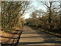
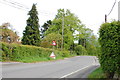
2
Nathan's Lane
Heading towards Edney Common.
Image: © Robin Webster
Taken: 22 Jul 2012
0.13 miles
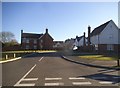
5
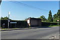
Bus stop, Edney Common
A Highwood Parish Council notice board is on the end of the bus shelter.
Image: © Robin Webster
Taken: 22 Jul 2012
0.18 miles
6
Highwood Road
Looking towards the footpath junction where the path heads north towards Bramwood Farm.
Image: © Trevor Harris
Taken: 4 May 2015
0.18 miles
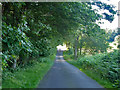
7
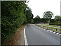
Highwood Road, Edney Common
Towards Chelmsford.
Image: © JThomas
Taken: 24 Aug 2022
0.19 miles
8
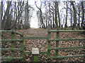
Stiles and footpath through Edney Wood
Image: © John Winfield
Taken: 9 Feb 2006
0.23 miles
9

Footpath through small wood, near Nathan's Lane, Edney Common
Image: © Roger Jones
Taken: 11 Mar 2017
0.23 miles
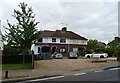
10
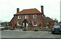
'The Green Man' inn
This inn stands along Highwood Road.
Image: © Robert Edwards
Taken: 22 Feb 2008
0.25 miles