IMAGES TAKEN NEAR TO
Ingatestone Road, CHELMSFORD, CM1 3QS
Introduction
This page details the photographs taken nearby to Ingatestone Road, CM1 3QS by members of the Geograph project.
The Geograph project started in 2005 with the aim of publishing, organising and preserving representative images for every square kilometre of Great Britain, Ireland and the Isle of Man.

There are currently over 7.5m images from over14,400 individuals and you can help contribute to the project by visiting https://www.geograph.org.uk
Image Map
Images are licensed for reuse under creativecommons.org/licenses/by-sa/2.0
Notes
- Clicking on the map will re-center to the selected point.
- The higher the marker number, the further away the image location is from the centre of the postcode.
Image Listing (15 Images Found)
Images are licensed for reuse under creativecommons.org/licenses/by-sa/2.0
Image
Details
Distance
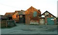
1
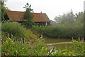
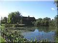
Gorrel's Farm Pond
The hedge has grown up considerably since John’s photo Image was taken in 2005
Image: © Glyn Baker
Taken: 22 Aug 2011
0.01 miles
2
Ingatestone Road
Looking towards the Old Forge
Image: © Glyn Baker
Taken: 22 Aug 2011
0.02 miles
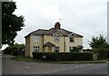
3
Ingatestone Road, Highwood
The house on the right corner has had the two floor extension added since 2009
Image: © David Howard
Taken: 25 Feb 2018
0.06 miles
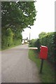
6
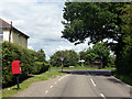
Post box and bus shelter at the junction
The junction being of Blackmore Road to the left, Highwood Road to the right and Ingatestone Road - all very descriptive of where they go.
Image: © Robin Webster
Taken: 28 Jul 2012
0.09 miles
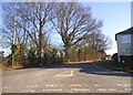
7
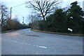
Ingatestone Road at the junction of Highwood Road
Image: © David Howard
Taken: 1 Jan 2023
0.09 miles
8
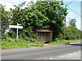
Bus shelter and unusual signpost
There is a bus stop sign, although well hidden. The signpost has the unusual direction 'Barrow Farm Riding for Disabled', the sign may not be of standard highway authority issue.
Image: © Robin Webster
Taken: 28 Jul 2012
0.09 miles
9
Pond and Barn, Gorrell's Farm
Looking south-west from Ingatestone Road
Image: © John Winfield
Taken: 20 Oct 2005
0.09 miles
10
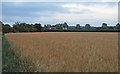
Barley Field near Ward's Farm, Highwood
Image: © Roger Jones
Taken: 8 Jul 2017
0.15 miles