IMAGES TAKEN NEAR TO
Fosters Close, CHELMSFORD, CM1 3NW
Introduction
This page details the photographs taken nearby to Fosters Close, CM1 3NW by members of the Geograph project.
The Geograph project started in 2005 with the aim of publishing, organising and preserving representative images for every square kilometre of Great Britain, Ireland and the Isle of Man.

There are currently over 7.5m images from over14,400 individuals and you can help contribute to the project by visiting https://www.geograph.org.uk
Image Map
Images are licensed for reuse under creativecommons.org/licenses/by-sa/2.0
Notes
- Clicking on the map will re-center to the selected point.
- The higher the marker number, the further away the image location is from the centre of the postcode.
Image Listing (11 Images Found)
Images are licensed for reuse under creativecommons.org/licenses/by-sa/2.0
Image
Details
Distance
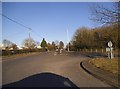
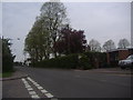
4
Roundabout on Ongar Road, Great Oxney Green
Image: © David Howard
Taken: 2 May 2012
0.11 miles
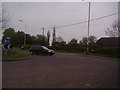
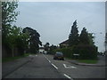
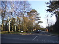
5
Ongar Road, Great Oxney Green
At the junction of Chequers Road
Image: © David Howard
Taken: 2 May 2012
0.14 miles
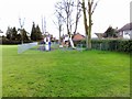
7
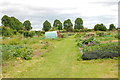
Great Oxney Green
Allotments occupy the largest area of the green.
Image: © Trevor Harris
Taken: 23 Jun 2013
0.17 miles
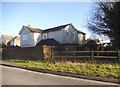
8
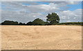
Recently Harvested Field, nr Great Oxney Green, Writtle
Image: © Roger Jones
Taken: 28 Jul 2018
0.18 miles
9
Redwood Drive at the junction of Ongar Road
Image: © David Howard
Taken: 25 Feb 2018
0.21 miles
10
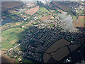
Great Oxley Green from the air
Looking north east over the town, Writtle College can be seen towards the top left corner.
Image: © Thomas Nugent
Taken: 14 Sep 2015
0.22 miles