IMAGES TAKEN NEAR TO
Chelmsford Road, CHELMSFORD, CM1 3ET
Introduction
This page details the photographs taken nearby to Chelmsford Road, CM1 3ET by members of the Geograph project.
The Geograph project started in 2005 with the aim of publishing, organising and preserving representative images for every square kilometre of Great Britain, Ireland and the Isle of Man.

There are currently over 7.5m images from over14,400 individuals and you can help contribute to the project by visiting https://www.geograph.org.uk
Image Map
Images are licensed for reuse under creativecommons.org/licenses/by-sa/2.0
Notes
- Clicking on the map will re-center to the selected point.
- The higher the marker number, the further away the image location is from the centre of the postcode.
Image Listing (14 Images Found)
Images are licensed for reuse under creativecommons.org/licenses/by-sa/2.0
Image
Details
Distance
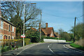
1
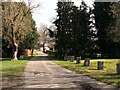
The approach to Skeggs Farm in Writtle
Image: © Robert Edwards
Taken: 12 Mar 2008
0.05 miles
3
Bridge over River Wid, Writtle
On the road to Chelmsford, plates each side advise 'Writtle Bridge 1891 Essex County Council'.
Image: © Robin Webster
Taken: 25 Mar 2012
0.09 miles
4

Old Bridge Marker by Bridge Street, Writtle Bridge, Writtle parish
Bridge Marker by the UC road, in parish of Writtle (Chelmsford District), Writtle Bridge over River Wid, set midway across on North parapet. Similar plaque on South parapet.
Inscription reads:-
WRITTLE BRIDGE
1891
{coat of arms}
ESSEX COUNTY COUNCIL
Essex HER.
SMR Number: 40255 https://www.heritagegateway.org.uk/Gateway/Results_Single.aspx?uid=MEX1034294&resourceID=1001
Surveyed
Milestone Society National ID: EX_WRIT01br
Image: © Milestone Society
Taken: Unknown
0.09 miles
5
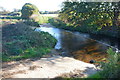
Ford at Skeggs Farm
This ford on the River Wid is found at Skeggs Farm.
Image: © John Walton
Taken: 6 Nov 2016
0.10 miles
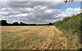
6
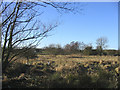
Rough Grazing by the River Wid
Dry meadows on the north side of River Wid near Writtle
Image: © John Winfield
Taken: 9 Feb 2006
0.13 miles
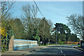
7
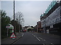
Bridge Street, Writtle
The bridge goes over the river Wid, just to the rear of this view. The new flats on the right are on the site of the old Inchcape Honda garage.
Image: © David Howard
Taken: 2 May 2012
0.13 miles
8
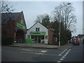
Co-operative stores, Bridge Street, Writtle
Image: © David Howard
Taken: 2 May 2012
0.15 miles
9
New houses on Bridge Street, Writtle
Apparently they will be in pseudo-old style, but are brand new, on the site of a Honda dealers.
Image: © Robin Webster
Taken: 25 Mar 2012
0.16 miles
10
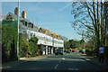
Mill House, Writtle
The house with the chimneys is grade II listed, late 19th century. A mill was on the River Wid, across the road, but there was also a windmill some way up behind the house, both are now gone.
Image: © Robin Webster
Taken: 25 Mar 2012
0.18 miles