IMAGES TAKEN NEAR TO
Thorndon Gate, BRENTWOOD, CM13 3RQ
Introduction
This page details the photographs taken nearby to Thorndon Gate, CM13 3RQ by members of the Geograph project.
The Geograph project started in 2005 with the aim of publishing, organising and preserving representative images for every square kilometre of Great Britain, Ireland and the Isle of Man.

There are currently over 7.5m images from over14,400 individuals and you can help contribute to the project by visiting https://www.geograph.org.uk
Image Map (Loading...)


Getting Data...Please wait
Leaflet Map data © OpenStreetMap
Images are licensed for reuse under creativecommons.org/licenses/by-sa/2.0
Notes
- Clicking on the map will re-center to the selected point.
- The higher the marker number, the further away the image location is from the centre of the postcode.
Image Listing (33 Images Found)
Images are licensed for reuse under creativecommons.org/licenses/by-sa/2.0
Image
Details
Distance
1
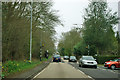
A128, Ingrave
Middle Road is on the right.
Image: © Robin Webster
Taken: 25 Mar 2012
0.10 miles
2
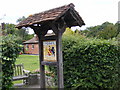
Ingrave Village Sign
On the A128 Brentwood Road
Image: © Geographer
Taken: 16 Aug 2008
0.15 miles
3
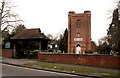
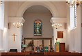
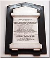
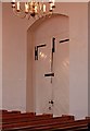
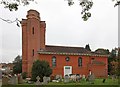
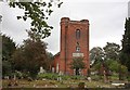
St. Nicholas' church, Ingrave, Essex
This church is entirely 18th century and it was erected by Lord Petre of Thorndon Hall in 1735. It has a massive red brick tower with polygonal turrets. The road in the picture is the A.128
Image: © Robert Edwards
Taken: 3 Jan 2007
0.15 miles