IMAGES TAKEN NEAR TO
Pear Trees, BRENTWOOD, CM13 3RP
Introduction
This page details the photographs taken nearby to Pear Trees, CM13 3RP by members of the Geograph project.
The Geograph project started in 2005 with the aim of publishing, organising and preserving representative images for every square kilometre of Great Britain, Ireland and the Isle of Man.

There are currently over 7.5m images from over14,400 individuals and you can help contribute to the project by visiting https://www.geograph.org.uk
Image Map
Images are licensed for reuse under creativecommons.org/licenses/by-sa/2.0
Notes
- Clicking on the map will re-center to the selected point.
- The higher the marker number, the further away the image location is from the centre of the postcode.
Image Listing (31 Images Found)
Images are licensed for reuse under creativecommons.org/licenses/by-sa/2.0
Image
Details
Distance
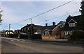
2
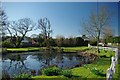
The Pond in Ingrave
A pleasant spot beside the A128
Image: © Glyn Baker
Taken: 19 Mar 2011
0.08 miles
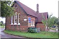
5
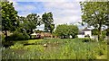
Hillcrest Nurseries, Ingrave Road
The entrance to Hillcrest Nurseries Ingrave.
Image: © Trevor Harris
Taken: 31 Jul 2008
0.16 miles
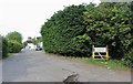
8
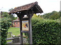
Ingrave Village Sign
On the A128 Brentwood Road
Image: © Geographer
Taken: 16 Aug 2008
0.17 miles
9
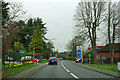
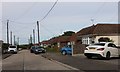
A128, Herongate
Hillcrest Nurseries on the left, Esso fuel station on the right. For the record, fuel prices displayed are 138.9 p/l petrol, 146.9 p/l diesel.
Image: © Robin Webster
Taken: 25 Mar 2012
0.18 miles