IMAGES TAKEN NEAR TO
Brentwood Road, BRENTWOOD, CM13 3LW
Introduction
This page details the photographs taken nearby to Brentwood Road, CM13 3LW by members of the Geograph project.
The Geograph project started in 2005 with the aim of publishing, organising and preserving representative images for every square kilometre of Great Britain, Ireland and the Isle of Man.

There are currently over 7.5m images from over14,400 individuals and you can help contribute to the project by visiting https://www.geograph.org.uk
Image Map
Images are licensed for reuse under creativecommons.org/licenses/by-sa/2.0
Notes
- Clicking on the map will re-center to the selected point.
- The higher the marker number, the further away the image location is from the centre of the postcode.
Image Listing (8 Images Found)
Images are licensed for reuse under creativecommons.org/licenses/by-sa/2.0
Image
Details
Distance
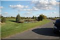
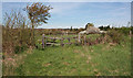
2
Part of the grounds at the South Essex Golf Club
Image: © Robert Edwards
Taken: 27 May 2009
0.14 miles
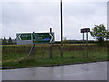
4
A128 Brentwood Road, East Horndon
Looking towards the A127 Southend Arterial Road at the junction with Brentwood Road
Image: © Geographer
Taken: 1 Oct 2010
0.19 miles
5
All Saints, East Horndon - Churchyard gate
Image: © John Salmon
Taken: 6 Apr 2011
0.23 miles
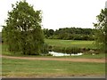
6
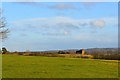
All Saints Church, East Horndon
All Saints Church, East Horndon. The Langdon Hills are in the background.
Image: © Adrian Benn
Taken: 1 Feb 2014
0.23 miles
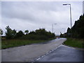
7
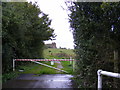
The entrance to All Saints Church, East Horndon
Off Brentwood Road
http://www.all-saints-east-horndon.co.uk/History.asp
http://en.wikipedia.org/wiki/All_Saints_Church,_East_Horndon
Image: © Geographer
Taken: 3 Oct 2010
0.23 miles
8
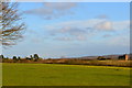
All Saints Church, East Horndon
All Saints Church, East Horndon, in a view from just south of the Octagon Plantation looking towards the Langdon Hills
Image: © Adrian Benn
Taken: 1 Feb 2014
0.24 miles