IMAGES TAKEN NEAR TO
Eagle Way, BRENTWOOD, CM13 3BN
Introduction
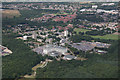
This page details the photographs taken nearby to Eagle Way, CM13 3BN by members of the Geograph project.
The Geograph project started in 2005 with the aim of publishing, organising and preserving representative images for every square kilometre of Great Britain, Ireland and the Isle of Man.

There are currently over 7.5m images from over14,400 individuals and you can help contribute to the project by visiting https://www.geograph.org.uk
Image Map
Images are licensed for reuse under creativecommons.org/licenses/by-sa/2.0
Notes
- Clicking on the map will re-center to the selected point.
- The higher the marker number, the further away the image location is from the centre of the postcode.
Image Listing (24 Images Found)
Images are licensed for reuse under creativecommons.org/licenses/by-sa/2.0
Image
Details
Distance
1

Old Boundary Marker by Clive Road, Brentwood parish
Estate Boundary Marker - War Department by the UC road, in parish of Brentwood (Brentwood District), Clive Road, Northeast corner of barracks at junction with Eagle Way.
Inscription reads:-
W^D
23
Surveyed
Milestone Society National ID: EX_WDBRE23em
Image: © Milestone Society
Taken: Unknown
0.01 miles
2
Beckett Close, Warley
Beckett Close in Warley, near Brentwood.
Image: © Malc McDonald
Taken: 28 Oct 2017
0.02 miles
3
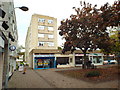
Local shops, Warley
A parade of local shops in a housing estate near Brentwood.
Image: © Malc McDonald
Taken: 28 Oct 2017
0.05 miles
5
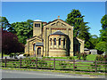
The chapel of the Royal Anglian Regiment and the Essex Regiment
According to the Brentwood Borough Council web site: "A grade II Listed Building, the Chapel was originally designed for the East India Company whose recruits were trained at Warley and built in 1857 after the Indian Mutiny. It was subsequently a garrison church until being dedicated as the Essex Regiment Chapel on 1st March, 1925."
Image: © Robin Webster
Taken: 26 May 2012
0.06 miles
6
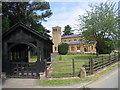
The Essex Regiment Chapel, Warley, Essex
Now referred to as the Anglian and Essex Regiment Chapel - situated alongside the old Warley Barracks.
Image: © John Winfield
Taken: 10 Jun 2005
0.06 miles
7
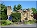
The chapel of the Royal Anglian Regiment and the Essex Regiment
A grade II listed building, the chapel was originally designed for the East India Company whose recruits were trained at Warley and built in 1857 after the Indian Mutiny. It was subsequently a garrison church until being dedicated as the Essex Regiment Chapel on 1st March, 1925.
Image: © Robin Webster
Taken: 26 May 2012
0.06 miles
8
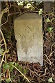
Old Boundary Marker by Eagle Way, Brentwood Parish
Estate Boundary Marker - War Department No.XXI by the UC road, in parish of Brentwood (Brentwood District), Eagle Way, North West corner of former barracks, in undergrowth.
Surveyed
Milestone Society National ID: EX_WDBRE21em
Image: © Milestone Society
Taken: Unknown
0.06 miles