IMAGES TAKEN NEAR TO
The Drive, BRENTWOOD, CM13 3BH
Introduction
This page details the photographs taken nearby to The Drive, CM13 3BH by members of the Geograph project.
The Geograph project started in 2005 with the aim of publishing, organising and preserving representative images for every square kilometre of Great Britain, Ireland and the Isle of Man.

There are currently over 7.5m images from over14,400 individuals and you can help contribute to the project by visiting https://www.geograph.org.uk
Image Map
Images are licensed for reuse under creativecommons.org/licenses/by-sa/2.0
Notes
- Clicking on the map will re-center to the selected point.
- The higher the marker number, the further away the image location is from the centre of the postcode.
Image Listing (24 Images Found)
Images are licensed for reuse under creativecommons.org/licenses/by-sa/2.0
Image
Details
Distance
1
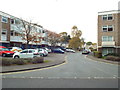
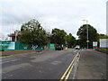
Canterbury Way, Warley
Canterbury Way is a short road in a housing estate near Brentwood.
Image: © Malc McDonald
Taken: 28 Oct 2017
0.07 miles
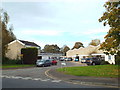
2
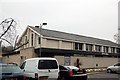
Keys Hall, Warley
Keys Hall is a public hall run and owned by Brentwood Borough Council. Though more recently extended and adapted, this was originally one of the buildings of Warley Barracks, which occupied this whole area between the early part of the 19th Century until they were closed in 1959. The main part of the Barracks was across the road from Keys Hall where the Ford offices are now. The Essex Regimental Chapel still survives.
Image: © Trevor Harris
Taken: 19 Mar 2009
0.09 miles
3
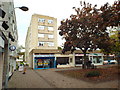
Local shops, Warley
A parade of local shops in a housing estate near Brentwood.
Image: © Malc McDonald
Taken: 28 Oct 2017
0.11 miles
6
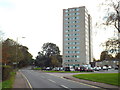
Gibraltar House, Warley
Gibraltar House is a high-rise block of flats in Warley, near Brentwood in Essex.
Image: © Malc McDonald
Taken: 28 Oct 2017
0.14 miles
7
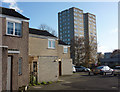
House and block of flats, Warley
Part of a varied residential and office area to the south of Brentwood.
Image: © Andrew Hill
Taken: 25 Nov 2009
0.14 miles
8
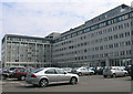
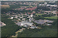
Ford UK & European Headquarters, Warley, Essex
Built on the site of the old Warley Barracks
Image: © John Winfield
Taken: 10 Jun 2005
0.14 miles
9

Old Boundary Marker by Clive Road, Brentwood parish
Estate Boundary Marker - War Department by the UC road, in parish of Brentwood (Brentwood District), Clive Road, Northeast corner of barracks at junction with Eagle Way.
Inscription reads:-
W^D
23
Surveyed
Milestone Society National ID: EX_WDBRE23em
Image: © Milestone Society
Taken: Unknown
0.15 miles
10
Beckett Close, Warley
Beckett Close in Warley, near Brentwood.
Image: © Malc McDonald
Taken: 28 Oct 2017
0.15 miles