IMAGES TAKEN NEAR TO
Newlands Close, BRENTWOOD, CM13 2SD
Introduction
This page details the photographs taken nearby to Newlands Close, CM13 2SD by members of the Geograph project.
The Geograph project started in 2005 with the aim of publishing, organising and preserving representative images for every square kilometre of Great Britain, Ireland and the Isle of Man.

There are currently over 7.5m images from over14,400 individuals and you can help contribute to the project by visiting https://www.geograph.org.uk
Image Map
Images are licensed for reuse under creativecommons.org/licenses/by-sa/2.0
Notes
- Clicking on the map will re-center to the selected point.
- The higher the marker number, the further away the image location is from the centre of the postcode.
Image Listing (15 Images Found)
Images are licensed for reuse under creativecommons.org/licenses/by-sa/2.0
Image
Details
Distance
1
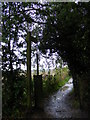
Footpath to Hanging Hill Lane & Church Lane
Off Hall Green Lane
Brentwood Footpath No.77
Image: © Geographer
Taken: 1 Oct 2010
0.19 miles
4
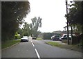
Hall Green Lane, Hutton
Near Hutton Cricket Club looking towards Hanging Hill Lane
Road No.U35576
Image: © Geographer
Taken: 1 Oct 2010
0.21 miles
5
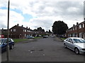
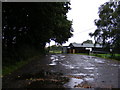
Springfield Avenue, Hutton
Road No.U35658
Image: © Geographer
Taken: 19 Sep 2015
0.21 miles
6
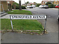
Springfield Avenue sign
On Springfield Avenue at the junction with Hutton Drive
Image: © Geographer
Taken: 19 Sep 2015
0.22 miles
7
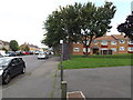
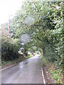
Hutton Drive, Hutton
At the junction with Springfield Avenue
Image: © Geographer
Taken: 19 Sep 2015
0.22 miles
8
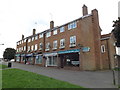
Parade of shops on Springfield Avenue
Off Hutton Drive
Image: © Geographer
Taken: 19 Sep 2015
0.22 miles
9
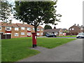
Springfield Avenue Postbox
On Springfield Avenue off Hutton Drive
Postbox No.CM13 69
Image: © Geographer
Taken: 19 Sep 2015
0.22 miles
10
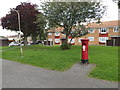
Springfield Avenue Postbox
On Springfield Avenue off Hutton Drive
Postbox No.CM13 69
Image: © Geographer
Taken: 19 Sep 2015
0.22 miles