IMAGES TAKEN NEAR TO
Heronway, BRENTWOOD, CM13 2LX
Introduction
This page details the photographs taken nearby to Heronway, CM13 2LX by members of the Geograph project.
The Geograph project started in 2005 with the aim of publishing, organising and preserving representative images for every square kilometre of Great Britain, Ireland and the Isle of Man.

There are currently over 7.5m images from over14,400 individuals and you can help contribute to the project by visiting https://www.geograph.org.uk
Image Map
Images are licensed for reuse under creativecommons.org/licenses/by-sa/2.0
Notes
- Clicking on the map will re-center to the selected point.
- The higher the marker number, the further away the image location is from the centre of the postcode.
Image Listing (13 Images Found)
Images are licensed for reuse under creativecommons.org/licenses/by-sa/2.0
Image
Details
Distance
4
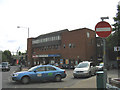
Shenfield Railway Station, Shenfield, Essex
Image: © John Winfield
Taken: 1 Jul 2005
0.14 miles
5
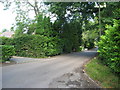
Brockley Grove from the Glase, Northwards
Image: © Steve Danby
Taken: 14 Sep 2008
0.15 miles
6
House being demolished, Brockley Grove
Image: © Alex McGregor
Taken: 31 Jan 2013
0.15 miles
7
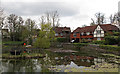
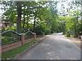
Roundwood Lake, Hutton
I wondered why this area wasn't on google streetview, when I got there I saw the "private road" signs, but of course that didn't put me off taking this for geograph.
Image: © Roger Jones
Taken: 13 Apr 2019
0.16 miles
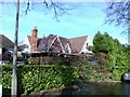
9
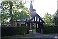
Shenfield and Hutton Union Church, Hutton Mount
Image: © Trevor Harris
Taken: 18 Sep 2008
0.18 miles