IMAGES TAKEN NEAR TO
St. Stephens Crescent, BRENTWOOD, CM13 2AT
Introduction
This page details the photographs taken nearby to St. Stephens Crescent, CM13 2AT by members of the Geograph project.
The Geograph project started in 2005 with the aim of publishing, organising and preserving representative images for every square kilometre of Great Britain, Ireland and the Isle of Man.

There are currently over 7.5m images from over14,400 individuals and you can help contribute to the project by visiting https://www.geograph.org.uk
Image Map
Images are licensed for reuse under creativecommons.org/licenses/by-sa/2.0
Notes
- Clicking on the map will re-center to the selected point.
- The higher the marker number, the further away the image location is from the centre of the postcode.
Image Listing (25 Images Found)
Images are licensed for reuse under creativecommons.org/licenses/by-sa/2.0
Image
Details
Distance
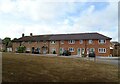
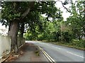
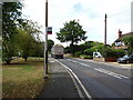
2
Running Waters, Brentwood
A very ordinary road on the edge of a small town, apart from the name.
Image: © Robert Eva
Taken: 11 Sep 2017
0.10 miles
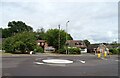
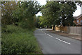
7
Junction on Brentwood Road
Turn right for The Avenue, left for Brentwood Road
Image: © David Howard
Taken: 25 May 2019
0.12 miles
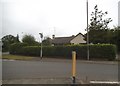
8
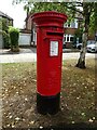
Elizabeth II postbox on Ingrave Road
Postbox No. CM13 12.
Image: © JThomas
Taken: 25 Aug 2022
0.12 miles
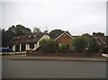
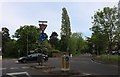
10
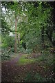
A Green Path in Brentwood
This green vein runs between the houses from Cherry Avenue to St Stephen's Crescent.
Image: © Glyn Baker
Taken: 6 Aug 2012
0.12 miles