IMAGES TAKEN NEAR TO
Padhams Green, BRENTWOOD, CM13 1UL
Introduction
This page details the photographs taken nearby to Padhams Green, CM13 1UL by members of the Geograph project.
The Geograph project started in 2005 with the aim of publishing, organising and preserving representative images for every square kilometre of Great Britain, Ireland and the Isle of Man.

There are currently over 7.5m images from over14,400 individuals and you can help contribute to the project by visiting https://www.geograph.org.uk
Image Map
Images are licensed for reuse under creativecommons.org/licenses/by-sa/2.0
Notes
- Clicking on the map will re-center to the selected point.
- The higher the marker number, the further away the image location is from the centre of the postcode.
Image Listing (20 Images Found)
Images are licensed for reuse under creativecommons.org/licenses/by-sa/2.0
Image
Details
Distance
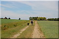
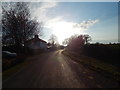
1
Church Road, Padham's Green
Looking towards Ingatestone Hall.
Image: © Hamish Griffin
Taken: 25 Mar 2015
0.03 miles
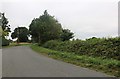
2
Church Road, Padham's Green
Looking towards Mountnessing.
Image: © Hamish Griffin
Taken: 25 Mar 2015
0.04 miles
3
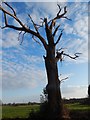
Dead tree, Padham's Green
On Church Road.
Image: © Hamish Griffin
Taken: 25 Mar 2015
0.04 miles
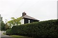
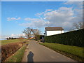
6
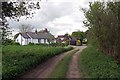
Padham's Green
The white cottage is called "The Old Bungalow" this is the end of the bridleway from Mountnessing Hall
Image: © Glyn Baker
Taken: 7 May 2015
0.07 miles