IMAGES TAKEN NEAR TO
Church Road, BRENTWOOD, CM13 1UH
Introduction
This page details the photographs taken nearby to Church Road, CM13 1UH by members of the Geograph project.
The Geograph project started in 2005 with the aim of publishing, organising and preserving representative images for every square kilometre of Great Britain, Ireland and the Isle of Man.

There are currently over 7.5m images from over14,400 individuals and you can help contribute to the project by visiting https://www.geograph.org.uk
Image Map
Images are licensed for reuse under creativecommons.org/licenses/by-sa/2.0
Notes
- Clicking on the map will re-center to the selected point.
- The higher the marker number, the further away the image location is from the centre of the postcode.
Image Listing (7 Images Found)
Images are licensed for reuse under creativecommons.org/licenses/by-sa/2.0
Image
Details
Distance
1
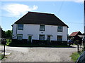
Begrums Farm, Church road, Mountnessing, Essex
Image: © Lorna Cowan
Taken: 27 Aug 2005
0.05 miles
2
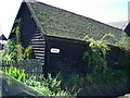
Begrums Farm, Church Road
This was taken in August 2005 and is on the boundary of Begrums Farm. My ancestors, the Samuels, were living here in 1800, probably moving here after the marriage of William in 1766 The farm itself dates from the fourteenth century.
Image: © Lorna Cowan
Taken: 27 Aug 2005
0.10 miles
3
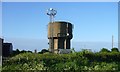
Water Tower
Water Tower at Begrums Farm, Arnolds Farm Lane, Mountnessing.
Image: © Sean Davis
Taken: 18 May 2008
0.11 miles
4
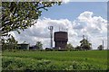
Water Tower & Telecoms Mast
Normally the telecoms antennas would be mounted on the water tower to save building a mast. I wonder why the water company didn't rent out the top of its tower.
Image: © Glyn Baker
Taken: 7 May 2015
0.12 miles
5
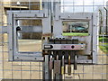
Access Denied
Security at Mountnessing water tower.
Image: © Peter Wood
Taken: 23 Feb 2015
0.13 miles
6
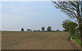
Looking to a Water Tower over Tilled Land, Mountnessing
Image: © Roger Jones
Taken: 22 Apr 2019
0.19 miles
7

Mountnessing Windmill, Mountnessing, Essex
Situated on north side of Roman Road, this is a traditional Post Windmill build in 1807. It has Grade II* listed status and restoration work is ongoing.
Image: © John Winfield
Taken: 15 Aug 2005
0.19 miles