IMAGES TAKEN NEAR TO
Rayleigh Road, BRENTWOOD, CM13 1PL
Introduction
This page details the photographs taken nearby to Rayleigh Road, CM13 1PL by members of the Geograph project.
The Geograph project started in 2005 with the aim of publishing, organising and preserving representative images for every square kilometre of Great Britain, Ireland and the Isle of Man.

There are currently over 7.5m images from over14,400 individuals and you can help contribute to the project by visiting https://www.geograph.org.uk
Image Map (Loading...)


Getting Data...Please wait
Leaflet Map data © OpenStreetMap
Images are licensed for reuse under creativecommons.org/licenses/by-sa/2.0
Notes
- Clicking on the map will re-center to the selected point.
- The higher the marker number, the further away the image location is from the centre of the postcode.
Image Listing (33 Images Found)
Images are licensed for reuse under creativecommons.org/licenses/by-sa/2.0
Image
Details
Distance
2
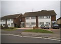
Tomlyns Close at the junction of Rayleigh Road
Image: © David Howard
Taken: 3 Sep 2017
0.11 miles
4
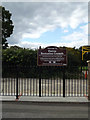
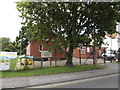
Hutton Recreation Grounds sign
Off Wash Road
Image: © Geographer
Taken: 19 Sep 2015
0.17 miles
5
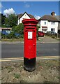
Elizabeth II postbox on Wash Road
Postbox No. CM13 36
Image: © JThomas
Taken: 26 Aug 2022
0.18 miles
6
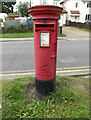
Wash Road Postbox
On Wash Road
Postbox No.CM13 36
(Close up)
Image: © Geographer
Taken: 19 Sep 2015
0.19 miles
7
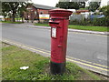
Wash Road Postbox
On Wash Road
Postbox No.CM13 36
Image: © Geographer
Taken: 19 Sep 2015
0.19 miles
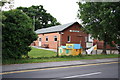
8
Hutton All Saints Scout Hut
Off Wash Road
Image: © Geographer
Taken: 19 Sep 2015
0.19 miles
10
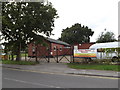
Hutton All Saints Scout Hut
Off Wash Road
Image: © Geographer
Taken: 19 Sep 2015
0.19 miles