IMAGES TAKEN NEAR TO
Claughton Way, BRENTWOOD, CM13 1JS
Introduction
This page details the photographs taken nearby to Claughton Way, CM13 1JS by members of the Geograph project.
The Geograph project started in 2005 with the aim of publishing, organising and preserving representative images for every square kilometre of Great Britain, Ireland and the Isle of Man.

There are currently over 7.5m images from over14,400 individuals and you can help contribute to the project by visiting https://www.geograph.org.uk
Image Map
Images are licensed for reuse under creativecommons.org/licenses/by-sa/2.0
Notes
- Clicking on the map will re-center to the selected point.
- The higher the marker number, the further away the image location is from the centre of the postcode.
Image Listing (22 Images Found)
Images are licensed for reuse under creativecommons.org/licenses/by-sa/2.0
Image
Details
Distance
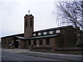
1
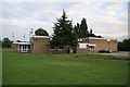
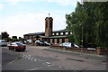
St.Peter's Church
On Claughton Way, Hutton
Image: © Geographer
Taken: 27 Feb 2012
0.02 miles
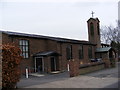
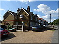
2
St.Peter's Church
On Claughton Way, Hutton
Image: © Geographer
Taken: 27 Feb 2012
0.02 miles
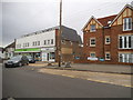
7
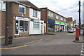
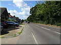
Local Shops in Rayleigh Road, Hutton
Shops at the junction of Rayleigh Road and Cedar Road. Despite the presence of much larger supermarkets quite nearby, several of the shops in this parade have remained in business for at least the past 35 years.
Image: © Graham Loveland
Taken: 20 Jun 2009
0.06 miles