IMAGES TAKEN NEAR TO
Woodland Avenue, BRENTWOOD, CM13 1HW
Introduction
This page details the photographs taken nearby to Woodland Avenue, CM13 1HW by members of the Geograph project.
The Geograph project started in 2005 with the aim of publishing, organising and preserving representative images for every square kilometre of Great Britain, Ireland and the Isle of Man.

There are currently over 7.5m images from over14,400 individuals and you can help contribute to the project by visiting https://www.geograph.org.uk
Image Map
Images are licensed for reuse under creativecommons.org/licenses/by-sa/2.0
Notes
- Clicking on the map will re-center to the selected point.
- The higher the marker number, the further away the image location is from the centre of the postcode.
Image Listing (32 Images Found)
Images are licensed for reuse under creativecommons.org/licenses/by-sa/2.0
Image
Details
Distance
1
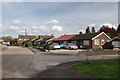
Bungalows in Pine Crescent
Most of this grid square is housing.
Image: © Glyn Baker
Taken: 7 May 2015
0.08 miles
2
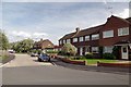
Harrison Close Hutton
Typical Hutton housing
Image: © Glyn Baker
Taken: 7 May 2015
0.16 miles
4
Tallon Road, Hutton
At the junction with Tallon Road
Image: © Geographer
Taken: 19 Sep 2015
0.19 miles
5
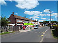
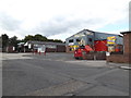
Local shops in Hutton, near Brentwood
A parade of local shops on Woodland Avenue in Hutton, Essex.
Image: © Malc McDonald
Taken: 7 Jun 2015
0.19 miles
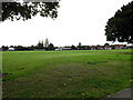
6
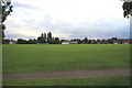
Playing Fields off Wash Road, Hutton
Image: © Graham Loveland
Taken: 20 Jun 2009
0.20 miles
7
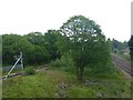
View from a footbridge
An impressive footbridge has to cross a double line and a single line separated by a wide area of grass in between seen here. This is the line between Shenfield and Billericay which was opened to passenger services on 1st January 1889 and continued on to Southend Victoria on 1st October of the same year. It diverges from the main line of 1843 to Chelmsford and Colchester about a quarter of a mile back towards Shenfield.
This view is of the northern single line on the left and the double line on the right looking in the direction of Billericay. On the north side of the footbridge the path passes alongside Arnold's Wood on its way to Lower Road and Mountnessing. The edge of Arnold's Wood can just be seen on the left.
Image: © Marathon
Taken: 17 May 2017
0.20 miles
8
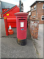
Tallon Road Postbox
On Tallon Road at the junction with Tallon Road
Postbox No.CM13 71
(Close up)
Image: © Geographer
Taken: 19 Sep 2015
0.20 miles
9
Tallon Road Postbox
On Tallon Road at the junction with Tallon Road
Postbox No.CM13 71
Image: © Geographer
Taken: 19 Sep 2015
0.20 miles
10
Tallon Road Postbox
On Tallon Road at the junction with Tallon Road
Postbox No.CM13 71
Image: © Geographer
Taken: 19 Sep 2015
0.20 miles