IMAGES TAKEN NEAR TO
Walton Gardens, BRENTWOOD, CM13 1EP
Introduction
This page details the photographs taken nearby to Walton Gardens, CM13 1EP by members of the Geograph project.
The Geograph project started in 2005 with the aim of publishing, organising and preserving representative images for every square kilometre of Great Britain, Ireland and the Isle of Man.

There are currently over 7.5m images from over14,400 individuals and you can help contribute to the project by visiting https://www.geograph.org.uk
Image Map (Loading...)


Getting Data...Please wait
Leaflet Map data © OpenStreetMap
Images are licensed for reuse under creativecommons.org/licenses/by-sa/2.0
Notes
- Clicking on the map will re-center to the selected point.
- The higher the marker number, the further away the image location is from the centre of the postcode.
Image Listing (15 Images Found)
Images are licensed for reuse under creativecommons.org/licenses/by-sa/2.0
Image
Details
Distance
1
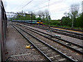
Approaching Shenfield, Essex
Looking east along the track on approaching Shenfield.
Image: © Christine Matthews
Taken: 8 May 2010
0.08 miles
2
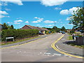
Arnolds Avenue, Hutton
Arnolds Aveunue in Hutton, near Brentwood.
Image: © Malc McDonald
Taken: 7 Jun 2015
0.10 miles
3

View from a footbridge
An impressive footbridge has to cross a double line and a single line separated by a wide area of grass in between. This is the line between Shenfield and Billericay which was opened to passenger services on 1st January 1889 and continued on to Southend Victoria on 1st October of the same year. It diverges from the main line of 1843 to Chelmsford and Colchester about a quarter of a mile back towards Shenfield.
This view is of the southern pair of lines looking back towards Shenfield. On the other side of the footbridge the path passes alongside Arnold's Wood on its way to Lower Road and Mountnessing.
Image: © Marathon
Taken: 17 May 2017
0.12 miles
4
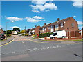
Long Ridings Avenue, Hutton
Long Ridings Avenue in Hutton, near Brentwood.
Image: © Malc McDonald
Taken: 7 Jun 2015
0.16 miles
5
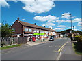
Local shops in Hutton, near Brentwood
A parade of local shops on Woodland Avenue in Hutton, Essex.
Image: © Malc McDonald
Taken: 7 Jun 2015
0.16 miles
6
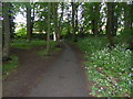
Path through woodland in Shenfield
A small park can be accessed from Woodland Avenue via a short footpath through this strip of woodland. This view is looking along the footpath back towards Woodland Avenue.
Image: © Marathon
Taken: 17 May 2017
0.18 miles
7
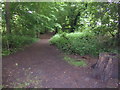
Woodland strip in Shenfield
A small park can be accessed from Woodland Avenue via a short footpath through this strip of woodland. This view is looking along the length of the woodland strip from the footpath.
Image: © Marathon
Taken: 17 May 2017
0.19 miles
8
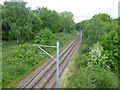
View from a footbridge
An impressive footbridge has to cross a double line and a single line separated by a wide area of grass in between. This is the line between Shenfield and Billericay which was opened to passenger services on 1st January 1889 and continued on to Southend Victoria on 1st October of the same year. It diverges from the main line of 1843 to Chelmsford and Colchester about a quarter of a mile back towards Shenfield.
This view is of the northern single line looking back towards Shenfield. On this side of the footbridge the path passes alongside Arnold's Wood on its way to Lower Road and Mountnessing.
Image: © Marathon
Taken: 17 May 2017
0.19 miles
9
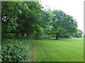
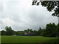
Park in Shenfield
This small park can be accessed from Woodland Avenue via a short footpath through a strip of woodland, or via Barnston Way on the other side. This view is after emerging from the path through the woodland strip.
Image: © Marathon
Taken: 17 May 2017
0.20 miles
10
Park in Shenfield
This small park can be accessed from Woodland Avenue via a short footpath through a strip of woodland, or via Barnston Way on the other side. This view is after emerging from the path through the woodland strip. Heavy rain was on its way in from the rest which continued for the whole evening and all night.
Image: © Marathon
Taken: 17 May 2017
0.20 miles