IMAGES TAKEN NEAR TO
Wheatfield Way, CHELMSFORD, CM1 2RB
Introduction
This page details the photographs taken nearby to Wheatfield Way, CM1 2RB by members of the Geograph project.
The Geograph project started in 2005 with the aim of publishing, organising and preserving representative images for every square kilometre of Great Britain, Ireland and the Isle of Man.

There are currently over 7.5m images from over14,400 individuals and you can help contribute to the project by visiting https://www.geograph.org.uk
Image Map (Loading...)


Getting Data...Please wait
Leaflet Map data © OpenStreetMap
Images are licensed for reuse under creativecommons.org/licenses/by-sa/2.0
Notes
- Clicking on the map will re-center to the selected point.
- The higher the marker number, the further away the image location is from the centre of the postcode.
Image Listing (37 Images Found)
Images are licensed for reuse under creativecommons.org/licenses/by-sa/2.0
Image
Details
Distance
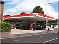
3

Petrol station on Rainsford Road, Chelmsford
Image: © David Howard
Taken: 25 Feb 2018
0.13 miles
4
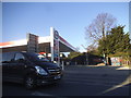
Petrol station on Rainsford Road, Chelmsford
Image: © David Howard
Taken: 25 Feb 2018
0.13 miles
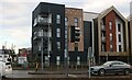
5
Hodgson House, Chelmsford
This is a block of offices which housed Galliford Try builders and is now residential.
Image: © David Howard
Taken: 12 Nov 2023
0.13 miles
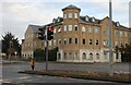
6
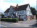
The Globe public house, Chelmsford
On Rainsford Road.
Image: © JThomas
Taken: 5 Aug 2017
0.13 miles
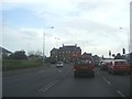
7
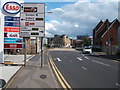
Rainsford Road, Chelmsford
Looking south east on the A1060.
Image: © JThomas
Taken: 5 Aug 2017
0.13 miles

9
Service station on Rainsford Road, Chelmsford
Image: © JThomas
Taken: 5 Aug 2017
0.14 miles
10

Sign for the Globe public house, Chelmsford
Image: © JThomas
Taken: 5 Aug 2017
0.14 miles