IMAGES TAKEN NEAR TO
Roxwell Road, CHELMSFORD, CM1 2NB
Introduction
This page details the photographs taken nearby to Roxwell Road, CM1 2NB by members of the Geograph project.
The Geograph project started in 2005 with the aim of publishing, organising and preserving representative images for every square kilometre of Great Britain, Ireland and the Isle of Man.

There are currently over 7.5m images from over14,400 individuals and you can help contribute to the project by visiting https://www.geograph.org.uk
Image Map (Loading...)


Getting Data...Please wait
Leaflet Map data © OpenStreetMap
Images are licensed for reuse under creativecommons.org/licenses/by-sa/2.0
Notes
- Clicking on the map will re-center to the selected point.
- The higher the marker number, the further away the image location is from the centre of the postcode.
Image Listing (19 Images Found)
Images are licensed for reuse under creativecommons.org/licenses/by-sa/2.0
Image
Details
Distance
1
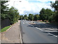
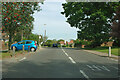
Roxwell Road (A1060), Chelmsford
Looking east.
Image: © JThomas
Taken: 5 Aug 2017
0.02 miles
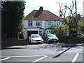
5
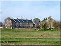
Houses, Windley Tye, Chelmsford
Newish in an old style.
Image: © Robin Webster
Taken: 25 Mar 2012
0.13 miles
7
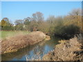
Bridge over River Cam, Chelmsford
In Admiral's Park, with Saffron Way path and marker
Image: © Chris Morgan
Taken: 3 Jun 2017
0.20 miles
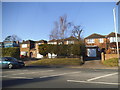
8
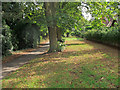
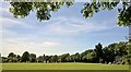
Trees and Green near Footpath, Chelmsford
Image: © Roger Jones
Taken: 15 Aug 2018
0.20 miles
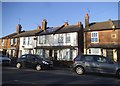
10
Chignall Road, Chelmsford
Heading north with Chignall Corner bus stop ahead.
Image: © Robin Webster
Taken: 15 Sep 2011
0.20 miles