IMAGES TAKEN NEAR TO
Avon Road, CHELMSFORD, CM1 2LD
Introduction
This page details the photographs taken nearby to Avon Road, CM1 2LD by members of the Geograph project.
The Geograph project started in 2005 with the aim of publishing, organising and preserving representative images for every square kilometre of Great Britain, Ireland and the Isle of Man.

There are currently over 7.5m images from over14,400 individuals and you can help contribute to the project by visiting https://www.geograph.org.uk
Image Map (Loading...)


Getting Data...Please wait
Leaflet Map data © OpenStreetMap
Images are licensed for reuse under creativecommons.org/licenses/by-sa/2.0
Notes
- Clicking on the map will re-center to the selected point.
- The higher the marker number, the further away the image location is from the centre of the postcode.
Image Listing (11 Images Found)
Images are licensed for reuse under creativecommons.org/licenses/by-sa/2.0
Image
Details
Distance
1
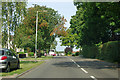
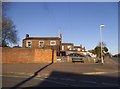
Chignall Road
A First bus is at the stop ahead.
Image: © Robin Webster
Taken: 15 Sep 2011
0.09 miles
3
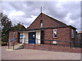
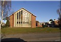
United Reformed Church Chelmsford Essex
Situated in Trent Road.
Image: © Peter Stack
Taken: 4 Sep 2009
0.20 miles
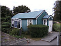
4
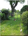
Avon Road allotments
Western fringe of Chelmsford
Image: © John Myers
Taken: 14 May 2008
0.21 miles
5
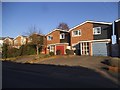
Chignal Road at the junction of Melbourne Avenue
Image: © David Howard
Taken: 25 Feb 2018
0.21 miles
8
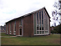
St. Andrew's church
This church stands on the corner of Chignall Road and Melbourne Avenue in an area of Chelmsford known as Melbourne.
Image: © Robert Edwards
Taken: 14 Apr 2008
0.24 miles
10
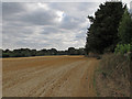
Crop Field Boundary and Hedgerow near Brickbarns Farm, Chignall
The public footpath as signposted on the ground is a little way from that shown on the map.
Image: © Roger Jones
Taken: 15 Aug 2018
0.25 miles