IMAGES TAKEN NEAR TO
Noak Hill Road, BILLERICAY, CM12 9UL
Introduction
This page details the photographs taken nearby to Noak Hill Road, CM12 9UL by members of the Geograph project.
The Geograph project started in 2005 with the aim of publishing, organising and preserving representative images for every square kilometre of Great Britain, Ireland and the Isle of Man.

There are currently over 7.5m images from over14,400 individuals and you can help contribute to the project by visiting https://www.geograph.org.uk
Image Map (Loading...)


Getting Data...Please wait
Leaflet Map data © OpenStreetMap
Images are licensed for reuse under creativecommons.org/licenses/by-sa/2.0
Notes
- Clicking on the map will re-center to the selected point.
- The higher the marker number, the further away the image location is from the centre of the postcode.
Image Listing (8 Images Found)
Images are licensed for reuse under creativecommons.org/licenses/by-sa/2.0
Image
Details
Distance
1

Noak Hill Golf Course, Essex
Looking north with the steeple of Great Burstead church visible on the skyline
Image: © John Winfield
Taken: 20 Oct 2005
0.06 miles
2
A176 towards Billericay
Near Noak Bridge.
Image: © Trevor Harris
Taken: 5 Feb 2016
0.15 miles
3
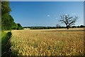
Footpath Nearing Noak Hill
This is the footpath from Dunton Road as it nears Noak Hill. Image flows behind the trees on the right
Image: © Glyn Baker
Taken: 22 Jul 2012
0.15 miles
5
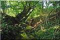
A Shady River Crouch
The River Crouch near Noak Hill
Image: © Glyn Baker
Taken: 22 Jul 2012
0.18 miles
6
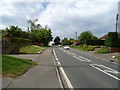
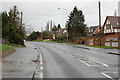
Noak Hill Road, Billericay
Looking north west on the A176.
Image: © JThomas
Taken: 11 May 2019
0.18 miles
7
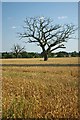
Dead Trees Near Noak Hill
A couple of oaks struck down in their prime it is a very sad sight
Image: © Glyn Baker
Taken: 22 Jul 2012
0.22 miles
8
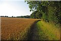
Footpath to Dunton Road
This is the footpath runs from Noak Hill to Dunton Road
Image: © Glyn Baker
Taken: 22 Jul 2012
0.24 miles