IMAGES TAKEN NEAR TO
London Road, BILLERICAY, CM12 9HP
Introduction
This page details the photographs taken nearby to London Road, CM12 9HP by members of the Geograph project.
The Geograph project started in 2005 with the aim of publishing, organising and preserving representative images for every square kilometre of Great Britain, Ireland and the Isle of Man.

There are currently over 7.5m images from over14,400 individuals and you can help contribute to the project by visiting https://www.geograph.org.uk
Image Map
Images are licensed for reuse under creativecommons.org/licenses/by-sa/2.0
Notes
- Clicking on the map will re-center to the selected point.
- The higher the marker number, the further away the image location is from the centre of the postcode.
Image Listing (15 Images Found)
Images are licensed for reuse under creativecommons.org/licenses/by-sa/2.0
Image
Details
Distance
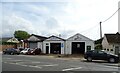
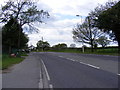
1
Bus stop on London Road, Shipmans
A129 towards Billericay.
Image: © JThomas
Taken: 25 Aug 2022
0.06 miles
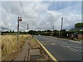
6
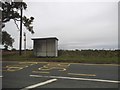
Bus stop on Rayleigh Road, Billericay
This is typical flat Essex countryside
Image: © David Howard
Taken: 3 Sep 2017
0.12 miles
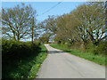
7
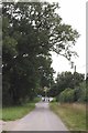
Approaching London Road
This private road is the end of Image that connects Mountnessing Road and London Road.
Image: © Glyn Baker
Taken: 1 Sep 2013
0.18 miles
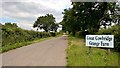
8
Road to Great Cowbridge Grange Farm
A private road but public footpath.
Image: © Robin Webster
Taken: 2 May 2013
0.19 miles
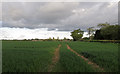
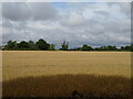
9
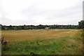
Fields Towards London Rd
A field between harvester and plough
Image: © Glyn Baker
Taken: 1 Sep 2013
0.22 miles