IMAGES TAKEN NEAR TO
The Avenue, BILLERICAY, CM12 9HG
Introduction
This page details the photographs taken nearby to The Avenue, CM12 9HG by members of the Geograph project.
The Geograph project started in 2005 with the aim of publishing, organising and preserving representative images for every square kilometre of Great Britain, Ireland and the Isle of Man.

There are currently over 7.5m images from over14,400 individuals and you can help contribute to the project by visiting https://www.geograph.org.uk
Image Map
Images are licensed for reuse under creativecommons.org/licenses/by-sa/2.0
Notes
- Clicking on the map will re-center to the selected point.
- The higher the marker number, the further away the image location is from the centre of the postcode.
Image Listing (5 Images Found)
Images are licensed for reuse under creativecommons.org/licenses/by-sa/2.0
Image
Details
Distance
2
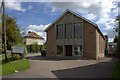
Western Road methodist church, Billericay
Image: © Robert Eva
Taken: 11 Sep 2017
0.17 miles
3
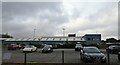
Billericay Station
Advertising hoardings on the down platform on the line between London Liverpool Street and Southend Victoria.
Image: © John Allan
Taken: 17 Apr 2013
0.23 miles
4
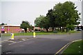
Gooseberry Green
The junction of Mountnessing Rd, Perry St and Radford Way
Image: © Glyn Baker
Taken: 1 Sep 2013
0.24 miles
5
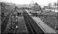
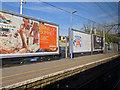
Billericay Station
View westwards, towards Shenfield and London; Shenfield - Southend (Victoria) line (electrified 1956).
Image: © Ben Brooksbank
Taken: 9 Apr 1961
0.25 miles