IMAGES TAKEN NEAR TO
Knightbridge Walk, BILLERICAY, CM12 0HP
Introduction
This page details the photographs taken nearby to Knightbridge Walk, CM12 0HP by members of the Geograph project.
The Geograph project started in 2005 with the aim of publishing, organising and preserving representative images for every square kilometre of Great Britain, Ireland and the Isle of Man.

There are currently over 7.5m images from over14,400 individuals and you can help contribute to the project by visiting https://www.geograph.org.uk
Image Map (Loading...)


Getting Data...Please wait
Leaflet Map data © OpenStreetMap
Images are licensed for reuse under creativecommons.org/licenses/by-sa/2.0
Notes
- Clicking on the map will re-center to the selected point.
- The higher the marker number, the further away the image location is from the centre of the postcode.
Image Listing (10 Images Found)
Images are licensed for reuse under creativecommons.org/licenses/by-sa/2.0
Image
Details
Distance
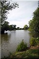
1
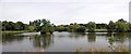
Lake Meadows Panorama
Lake Meadows Park is in the centre of Billericay
Image: © Glyn Baker
Taken: 3 Sep 2013
0.12 miles
2

Play area Lake Meadows Park
For the older children, behind the swimming pool.
Image: © Chris Morgan
Taken: 27 Dec 2012
0.13 miles
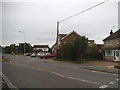
3
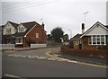
Perry Street at the junction of Wick Green
Image: © David Howard
Taken: 3 Sep 2017
0.14 miles

7
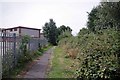
Path to Gooseberry Green
This urban footpath runs beside an industrial estate
Image: © Glyn Baker
Taken: 1 Sep 2013
0.23 miles
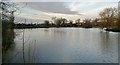
10
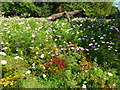
Lake Meadows
Flower meadow at the lakeside.
Image: © Ian Paterson
Taken: 8 Sep 2014
0.25 miles