IMAGES TAKEN NEAR TO
Whitesmith Drive, BILLERICAY, CM12 0FP
Introduction
This page details the photographs taken nearby to Whitesmith Drive, CM12 0FP by members of the Geograph project.
The Geograph project started in 2005 with the aim of publishing, organising and preserving representative images for every square kilometre of Great Britain, Ireland and the Isle of Man.

There are currently over 7.5m images from over14,400 individuals and you can help contribute to the project by visiting https://www.geograph.org.uk
Image Map (Loading...)


Getting Data...Please wait
Leaflet Map data © OpenStreetMap
Images are licensed for reuse under creativecommons.org/licenses/by-sa/2.0
Notes
- Clicking on the map will re-center to the selected point.
- The higher the marker number, the further away the image location is from the centre of the postcode.
Image Listing (15 Images Found)
Images are licensed for reuse under creativecommons.org/licenses/by-sa/2.0
Image
Details
Distance
1
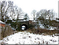
Tunnel under the Railway
I'm not sure what this tunnel under the Southend Victoria to London Liverpool Street Railway Line on the outskirts of Billericay is used for. It looks fairly substantial but apart from possibly farm use I don't know. I pointed the camera through a rather large security fence to take this.
Image: © terry joyce
Taken: 8 Feb 2012
0.09 miles
2
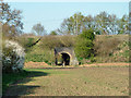
Underbridge on Southend Victoria line
A farm accommodation bridge. At first I assumed it was for, or shared with, the small brook that passes under the line hereabouts. On looking closer, the brook has its own small culvert somewhat to the left, hidden by the hedge that follows the brook.
Image: © Robin Webster
Taken: 2 May 2013
0.10 miles
3
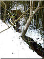
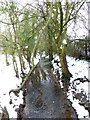
River Wid?
It is likely this is part of or a tributary of the River Wid. It appears from under the Mountnessing Road. This section is flowing under the railway line.
Image: © terry joyce
Taken: 8 Feb 2012
0.12 miles
4
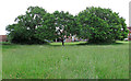
Trees in Meadow, nr Pleasant Drive, Billericay
Meadow looks like a recreation ground.
Image: © Roger Jones
Taken: 27 May 2019
0.14 miles
5
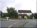
The Pilgrim Public House, Billericay
Located in an area called Gooseberry Green - this pub is at junction of Mountnessing Road and Radford Way.
Image: © John Winfield
Taken: 16 Sep 2005
0.16 miles
6
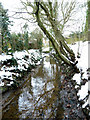
River Wid?
It is likely this is part of or a tributary of the River Wid. It appears from under the Mountnessing Road. This section is in a small woodland reached from Pleasant Drive. It flows under the railway line further south in the grid.
Image: © terry joyce
Taken: 8 Feb 2012
0.20 miles
7
Train on Southend Victoria line
Between Shenfield and Billericay.
Image: © Robin Webster
Taken: 2 May 2013
0.21 miles
8
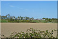
Track east from Great Cowbridge Grange Farm
The fringe of Billericay in the distance.
Image: © Robin Webster
Taken: 2 May 2013
0.21 miles
9
River Wid?
It is likely this is part of or a tributary of the River Wid. This section appears from under the Mountnessing Road flowing towards where I was standing.
It flows under the railway line further south in the grid.
Image: © terry joyce
Taken: 8 Feb 2012
0.22 miles
10
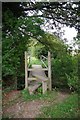
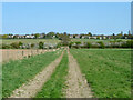
Stile & Footbridge on FP11
Footbridge over a deep ditch on Footpath 11
Image: © Glyn Baker
Taken: 1 Sep 2013
0.23 miles