IMAGES TAKEN NEAR TO
Mountnessing Road, BILLERICAY, CM12 0EU
Introduction
This page details the photographs taken nearby to Mountnessing Road, CM12 0EU by members of the Geograph project.
The Geograph project started in 2005 with the aim of publishing, organising and preserving representative images for every square kilometre of Great Britain, Ireland and the Isle of Man.

There are currently over 7.5m images from over14,400 individuals and you can help contribute to the project by visiting https://www.geograph.org.uk
Image Map (Loading...)


Getting Data...Please wait
Leaflet Map data © OpenStreetMap
Images are licensed for reuse under creativecommons.org/licenses/by-sa/2.0
Notes
- Clicking on the map will re-center to the selected point.
- The higher the marker number, the further away the image location is from the centre of the postcode.
Image Listing (8 Images Found)
Images are licensed for reuse under creativecommons.org/licenses/by-sa/2.0
Image
Details
Distance
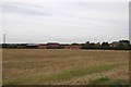
3
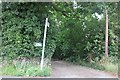
Path at the end of Linda Gardens, Billericay
Image: © David Howard
Taken: 4 Jul 2020
0.09 miles
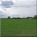
5
Little Crowbridge Grange
A substantial collection of farm buildings with electricity supplied by a wind turbine
Image: © Glyn Baker
Taken: 1 Sep 2013
0.17 miles
6
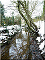
River Wid?
It is likely this is part of or a tributary of the River Wid. This section appears from under the Mountnessing Road flowing towards where I was standing.
It flows under the railway line further south in the grid.
Image: © terry joyce
Taken: 8 Feb 2012
0.20 miles
7
Looking to a Wind Turbine nr. Little Cowbridge Grange, Billericay
Image: © Roger Jones
Taken: 6 May 2019
0.22 miles
8
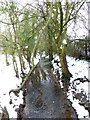
River Wid?
It is likely this is part of or a tributary of the River Wid. It appears from under the Mountnessing Road. This section is in a small woodland reached from Pleasant Drive. It flows under the railway line further south in the grid.
Image: © terry joyce
Taken: 8 Feb 2012
0.22 miles